Heat Advisory issued June 26 at 3:14PM EDT until June 27 at 8:00PM EDT by NWS Wilmington OH (details ...)
* WHAT...Heat index values in the upper 90s to lower 100s.
* WHERE...Portions of east central and southeast Indiana, northeast and northern Kentucky, and central, south central, southwest, and west central Ohio.
* WHEN...Until 8 PM EDT Friday.
* IMPACTS...Hot temperatures and high humidity may cause heat illnesses.
* ADDITIONAL DETAILS...Consecutive days of high heat and humidity can be especially hazardous as warm overnight temperatures will provide little relief.
Flood Advisory issued June 26 at 5:42PM EDT until June 26 at 8:45PM EDT by NWS Wilmington OH (details ...)
* WHAT...Flooding caused by excessive rainfall is expected.
* WHERE...The following county, in west central Ohio, Auglaize.
* WHEN...Until 845 PM EDT.
* IMPACTS...Minor flooding in low-lying and poor drainage areas.
* ADDITIONAL DETAILS... - At 542 PM EDT, radar indicated heavy rain due to thunderstorms. Minor flooding is ongoing or expected to begin shortly in the advisory area. Between 1 and 2 inches of rain have fallen. Additional rainfall amounts of 0.5 to 1 inch are possible. - Some locations that may experience flooding include... Wapakoneta, Fort Shawnee, Cridersville, Waynesfield, Uniopolis, St. Johns, Fryburg and New Hampshire.
Today 90° Today 90° chance 75° 75° chance Tomorrow 90° Tomorrow 90° likely 73° 73° likely chance
Wednesday, June 25th, 2008
Photo by Mark Pummell/The Daily Standard

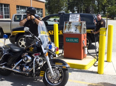
Mercer County Sheriff Deputy Jerry Wolford takes off his helmet before refueling his motorcycle as Lt. Matt Grunden refuels an SUV before heading out on patrol Tuesday morning. The sheriff's office, like other law enforcement agencies throughout the area, is feeling the impact of rising fuel costs.

Related online story:
Area motorists are not the only ones feeling the pinch at the gas pump. Law enforcement agencies share the pain in the wake of soaring prices.
Thos [More]
Additional pictures on this date