Special Weather Statement issued April 29 at 5:02PM EDT by NWS Wilmington OH (details ...)
At 459 PM EDT, gusty showers were located along a line extending from near Ada to near Northridge, moving east at 25 mph. Some of these showers are capable of producing funnel clouds and isolated thunder.
HAZARD...Funnel clouds and wind gusts up to 40 mph.
SOURCE...Radar indicated.
IMPACT...Gusty winds could knock down tree limbs and blow around unsecured objects.
Locations impacted include... Marysville, Bellefontaine, Urbana, Kenton, Ada, Plain City, Richwood, St. Paris, West Liberty, Mechanicsburg, North Lewisburg, Forest, Russells Point, De Graff, Lakeview, Dunkirk, Alger, Belle Center, West Mansfield, and Chippewa Park.
Conditions are favorable for the development of weak, brief funnel clouds. This type of funnel cloud is harmless, but on rare occasions they can briefly touch down, producing wind gusts over 50 mph. If a funnel cloud is spotted move indoors and report your sighting to the National Weather Service.
If outdoors, consider seeking shelter inside a sturdy building.
To report hazardous weather conditions, go to our website at weather.gov/iln and submit your report via social media, when you can do so safely.
Today 60° Today 60° likely 39° 39° slight chance Tomorrow 56° Tomorrow 56° 39° 39°
Wednesday, January 4th, 2012
Fall tillage in winter
Photo by Shelley Grieshop/The Daily Standard

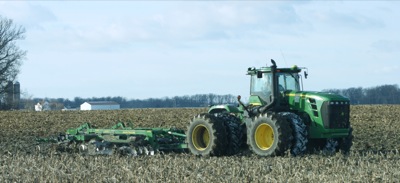
Area farmers, such as this one along Burkettsville-St. Henry Road in rural Coldwater, were busy Tuesday turning the soil in fields that finally were dry enough to enter. Fall tillage is typically completed in November, but this year wet weather delayed planting and harvest. Some corn and soybeans still remain in the fields, said Mike Baucher, a program technician with the Mercer County Farm Service Agency. Farmers typically are finished with harvest by Nov. 15.

Additional pictures on this date