Winter Storm Watch issued January 22 at 1:34PM EST until January 26 at 1:00AM EST by NWS Wilmington OH (details ...)
* WHAT...Heavy snow possible. Total snow accumulations between 4 and 7 inches possible. * WHERE...Auglaize, Darke, Hardin, Logan, Mercer, and Shelby Counties. * WHEN...From Saturday morning through late Sunday night. * IMPACTS...Travel could be very difficult.
Cold Weather Advisory issued January 22 at 12:34PM EST until January 23 at 12:00PM EST by NWS Wilmington OH (details ...)
* WHAT...Very cold wind chills as low as 13 below zero expected. * WHERE...In Indiana, Wayne County. In Ohio, Auglaize, Darke, Hardin, Logan, Mercer, and Shelby Counties. * WHEN...From 6 AM to noon EST Friday. * IMPACTS...Wind chill values can lead to hypothermia with prolonged exposure. * ADDITIONAL DETAILS...While temperatures are expected to be in the upper single digits (above zero), a northwest wind at 10-15 mph will make temperatures feel as if they are colder than 10 below zero.
Saturday, June 2nd, 2012
Photo by Mark Pummell/The Daily Standard
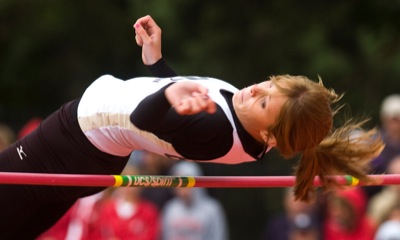
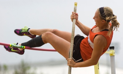
Parkway's Bailey King goes over the bar during the Division III high jump on Friday at the state track meet in Columbus. King finished second after a jump off against Columbus Grove's Riley Eversole.
COLUMBUS - Field events dominated the action for local athletes on Friday at the state track meet. The finals were completed in all field events involving local athletes with the exception of Division II's long jump and pole vault. [More]