Blowing Dust Advisory issued March 13 at 3:16PM EDT until March 13 at 8:00PM EDT by NWS Wilmington OH (details ...)
* WHAT...For the Blowing Dust Advisory, visibility between one-quarter and one mile in blowing dust. For the High Wind Warning, west winds 25 to 35 mph with gusts up to 65 mph. * WHERE...Auglaize, Hardin, and Mercer Counties. * WHEN...Until 8 PM EDT this evening. * IMPACTS...Hazardous driving conditions due to reduced visibility. Damaging winds will blow down trees and power lines. Widespread power outages are expected. Travel will be difficult, especially for high profile vehicles.
High Wind Warning issued March 13 at 3:16PM EDT until March 13 at 8:00PM EDT by NWS Wilmington OH (details ...)
* WHAT...For the Blowing Dust Advisory, visibility between one-quarter and one mile in blowing dust. For the High Wind Warning, west winds 25 to 35 mph with gusts up to 65 mph. * WHERE...Auglaize, Hardin, and Mercer Counties. * WHEN...Until 8 PM EDT this evening. * IMPACTS...Hazardous driving conditions due to reduced visibility. Damaging winds will blow down trees and power lines. Widespread power outages are expected. Travel will be difficult, especially for high profile vehicles.
Special Weather Statement issued March 13 at 2:44PM EDT by NWS Wilmington OH (details ...)
Very strong wind gusts and dry soil is leading to areas of blowing dust across the area. This is causing visibility to be reduced to one mile or less in localized area. Motorists should be prepared for rapidly changing visibility. Slow down and leave plenty of distance between you and the vehicle in front of you. As winds slowly decrease late this afternoon into the evening, blowing dust should diminish.
Wednesday, December 18th, 2013
You're a mean one
Photo by Mark Pummell/The Daily Standard
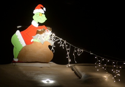
The Grinch is seen stealing Christmas lights from a rooftop on Elm Street in Coldwater on Tuesday evening. The mean green one may get a bit wet as rain moves into the area Thursday. The high is expected to reach 38.