Flood Advisory issued July 11 at 3:58PM EDT until July 11 at 7:00PM EDT by NWS Wilmington OH (details ...)
* WHAT...Flooding caused by excessive rainfall is expected.
* WHERE...The following counties, in west central Ohio, Auglaize, Darke, Mercer and Shelby.
* WHEN...Until 700 PM EDT.
* IMPACTS...Minor flooding in low-lying and poor drainage areas.
* ADDITIONAL DETAILS... - At 356 PM EDT, radar indicated heavy rain due to thunderstorms. Minor flooding is ongoing or expected to begin shortly in the advisory area. Between 1 and 2 inches of rain have fallen. Additional rainfall amounts of 0.5 to 1 inch are possible. - Some locations that may experience flooding include... Fort Loramie, New Bremen, Minster, Newport, New Knoxville, Russia, Osgood, Willowdell, Chickasaw, Kettlersville, Yorkshire, Lake Loramie State Park, Egypt, Maria Stein, Mccartyville and Houston.
Today 81° Today 81° chance 67° 67° chance Tomorrow 83° Tomorrow 83° 66° 66°
Tuesday, July 18th, 2017
Photo by Mark Pummell/The Daily Standard

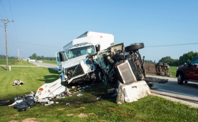
Two semitrailers block State Route 29 after a collision this morning. The darker semi flipped when it collided with a gray car at the intersection of State Route 29 and State Route 118/Burkettsville-St. Henry Road. The cab was then struck by another semi headed eastbound on State Route 29.

Related online story:

CELINA - A three-vehicle collision this morning at the intersection of State Route 118/Burkettsville-St. Henry Road and State Route 29 has left one driver in critical condition, Mercer County Sheriff Jeff Grey said at the scene. [More]
Additional pictures on this date