Severe Thunderstorm Watch issued March 31 at 6:02PM EDT until April 1 at 12:00AM EDT by NWS Wilmington OH (details ...)
THE NATIONAL WEATHER SERVICE HAS ISSUED SEVERE THUNDERSTORM WATCH 82 IN EFFECT UNTIL MIDNIGHT EDT TONIGHT FOR THE FOLLOWING AREAS IN OHIO THIS WATCH INCLUDES 3 COUNTIES IN WEST CENTRAL OHIO AUGLAIZE HARDIN MERCER THIS INCLUDES THE CITIES OF ADA, CELINA, COLDWATER, KENTON, MINSTER, NEW BREMEN, ST. MARYS, AND WAPAKONETA.
Friday, March 23rd, 2018
Crash investigated
Photo by Tom Stankard/The Daily Standard
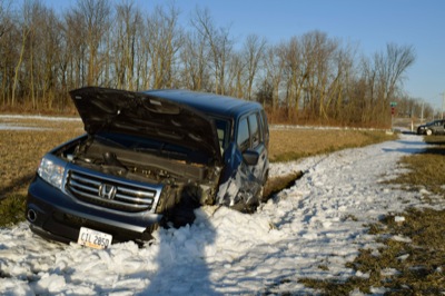
A Honda minivan sits in a ditch along Sharpsburg Road near St. Peter Road outside Fort Recovery following a two-vehicle accident this morning. Both vehicles sustained disabling damage. No more information was available at press time.