Extreme Heat Warning issued July 3 at 11:21AM EDT until July 3 at 8:00PM EDT by NWS Wilmington OH (details ...)
* WHAT...For the Extreme Heat Warning, dangerously hot conditions with heat index values around 105 are expected. For the Heat Advisory, heat index values around 100 are expected.
* WHERE...Portions of east central and southeast Indiana, northeast and northern Kentucky, and central, south central, southwest, and west central Ohio.
* WHEN...For the Extreme Heat Warning, until 8 PM EDT this evening. For the Heat Advisory, from 8 PM this evening to 8 PM EDT Saturday.
* IMPACTS...Heat related illnesses increase significantly during extreme heat and high humidity events, particularly for those working or participating in outdoor activities. Hot temperatures and high humidity may cause heat illnesses.
* ADDITIONAL DETAILS...Remember, multiple days with excessive heat can have compounding effects.
Heat Advisory issued July 3 at 11:21AM EDT until July 4 at 8:00PM EDT by NWS Wilmington OH (details ...)
* WHAT...For the Extreme Heat Warning, dangerously hot conditions with heat index values around 105 are expected. For the Heat Advisory, heat index values around 100 are expected.
* WHERE...Portions of east central and southeast Indiana, northeast and northern Kentucky, and central, south central, southwest, and west central Ohio.
* WHEN...For the Extreme Heat Warning, until 8 PM EDT this evening. For the Heat Advisory, from 8 PM this evening to 8 PM EDT Saturday.
* IMPACTS...Heat related illnesses increase significantly during extreme heat and high humidity events, particularly for those working or participating in outdoor activities. Hot temperatures and high humidity may cause heat illnesses.
* ADDITIONAL DETAILS...Remember, multiple days with excessive heat can have compounding effects.
Special Weather Statement issued July 3 at 7:22PM EDT by NWS Wilmington OH (details ...)
At 722 PM EDT, a strong thunderstorm was located near Wapakoneta, moving east at 45 mph.
HAZARD...Wind gusts up to 40 mph.
SOURCE...Radar indicated.
IMPACT...Gusty winds could knock down tree limbs and blow around unsecured objects.
Locations impacted include... Wapakoneta, St. Marys, Fort Shawnee, Cridersville, New Knoxville, Waynesfield, Moulton, Buckland, Uniopolis, Fryburg, Kossuth, St. Johns, and New Hampshire.
This includes I-75 in Ohio between mile markers 107 and 118.
If outdoors, consider seeking shelter inside a sturdy building.
To report hazardous weather conditions, go to our website at weather.gov/iln and submit your report via social media, when you can do so safely.
Today 93° Today 93° slight chance 75° 75° chance Tomorrow 90° Tomorrow 90° slight chance 72° 72° chance likely
Saturday, April 25th, 2026
Obituaries on April 25th, 2026
There are no obituaries on this date.
Stories on April 25th, 2026
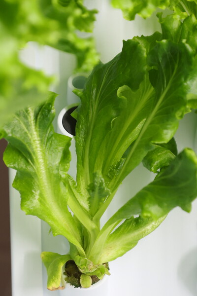
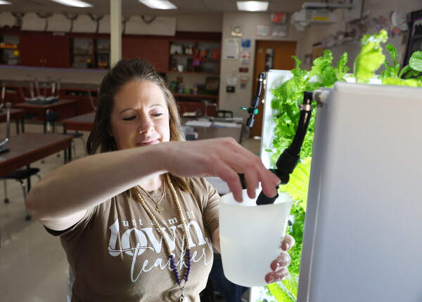
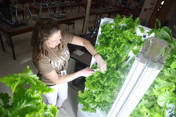
Classroom lettuce crop is a hit with middle schoolers
FORT RECOVERY - The produce growing inside of Fort Recovery Middle School isn't just a science project - it's what's for lunch.
In a collaborati [More]
CELINA - A 51-year-old Celina man wanted in both Mercer and Darke counties was taken into custody Friday in Celina by a special response team, a news release from Sheriff Doug Timmerman states.
MARIA STEIN - A new building dubbed Stein Plaza will go up soon in the Marion Industrial Park, providing 7,500 square feet of space for a new optometry business as well as the expansion of other established firms.
St. Marys picks up WBL softball win over Wapakoneta
ST. MARYS - Eddie Rabbit's classic tune "I Love a Rainy Night" played over the loudspeakers at the conclusion of Friday night's St. Marys-Wapakoneta softball game.
Compiled by Gary R. Rasberry
The St. Marys girls track and field team captured the team championship at the Joe Ward Invitational hosted by Sidney High School at Sidney Memorial Stadium.
Local pictures on April 25th, 2026