Flood Warning issued September 18 at 12:21AM EDT until September 18 at 8:00AM EDT by NWS Wilmington OH (details ...)
* WHAT...Flooding caused by excessive rainfall continues.
* WHERE...Northwestern Auglaize County in west central Ohio... Mercer County in west central Ohio...
* WHEN...Until 800 AM EDT Friday.
* IMPACTS...Numerous roads remain closed due to flooding. Expect many areas of slow moving or standing water.
* ADDITIONAL DETAILS... - At 1218 AM EDT, radar indicated scattered thunderstorms developing which contain moderate to heavy rainfall. Flooding is ongoing or expected to begin shortly in the warned area. Additional rainfall amounts of 0.5 to 1 inch are possible in the warned area over the next hour or two. - Some locations that may experience flooding include... Celina, St. Marys, Coldwater, New Bremen, Rockford, Wabash, Mendon, Chickasaw, Montezuma, Tama, Neptune, Carthagena, Bulkhead, State Route 116 at State Route 197, Chattanooga and Kossuth.
65° 65° chance Fri 77° Fri 77° 60° 60° Sat 78° Sat 78° likely
Friday, November 3rd, 2006
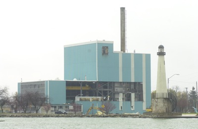
Partially plucked Blue Goose
Photo by Mark Pummell/The Daily Standard

The interior of the Blue Goose now is exposed as demolition of the old power plant continues this week. B&B Wrecking, Cleveland, is paying the city $26,000 for the right to take down the structure and salvage the scap metal from the site. The 1-acre parcel eventually will serve as the site for a new water treatment process being adding to the city's current system.


Additional pictures on this date