Flood Advisory issued August 19 at 6:30PM EDT until August 19 at 9:00PM EDT by NWS Wilmington OH (details ...)
* WHAT...Flooding caused by excessive rainfall continues.
* WHERE...Southern Mercer County in west central Ohio...
* WHEN...Until 900 PM EDT.
* IMPACTS...Minor flooding in low-lying and poor drainage areas.
* ADDITIONAL DETAILS... - At 630 PM EDT, radar indicated heavy rain due to thunderstorms. Minor flooding is ongoing or expected to begin shortly in the advisory area. Between 1 and 2 inches of rain have fallen. Additional rainfall amounts of 0.5 to 1 inch are possible. - Some locations that may experience flooding include... Coldwater, St. Henry, Fort Recovery, Chickasaw, Burkettsville, Montezuma, Carthagena and Maria Stein.
Flood Watch issued August 19 at 12:40PM EDT until August 20 at 10:00AM EDT by NWS Wilmington OH (details ...)
* WHAT...Flash flooding caused by excessive rainfall is possible.
* WHERE...Portions of east central Indiana, including the following counties, Fayette, Union and Wayne and Ohio, including the following counties, Auglaize, Champaign, Clark, Darke, Delaware, Fairfield, Fayette, Franklin, Greene, Hardin, Hocking, Licking, Logan, Madison, Mercer, Miami, Montgomery, Pickaway, Preble, Shelby and Union.
* WHEN...From 4 PM EDT this afternoon through Thursday morning.
* IMPACTS...Excessive runoff may result in flooding of rivers, creeks, streams, and other low-lying and flood-prone locations.
* ADDITIONAL DETAILS... - A complex of storms will develop later this afternoon and continue overnight. Repeated rounds of storms, combined with the extremely wet soil conditions will increase the risk for flash flooding later this evening into the overnight hours.
Flood Advisory issued August 19 at 6:33PM EDT until August 19 at 10:30PM EDT by NWS Wilmington OH (details ...)
* WHAT...Flooding caused by excessive rainfall continues.
* WHERE...Southern Auglaize County in west central Ohio... Northwestern Logan County in west central Ohio... Northern Shelby County in west central Ohio...
* WHEN...Until 1030 PM EDT.
* IMPACTS...Minor flooding in low-lying and poor drainage areas. Water over roadways.
* ADDITIONAL DETAILS... - At 633 PM EDT, radar and automated rain gauges indicated heavy rain due to thunderstorms. Minor flooding is ongoing or expected to begin shortly in the advisory area. Between 1 and 2 inches of rain have fallen. Additional rainfall amounts of 0.5 to 1 inch are possible. - Some locations that may experience flooding include... New Bremen, Minster, Jackson Center, Russells Point, Botkins, Lakeview, Huntsville, Kettlersville, Montra, Mccartyville, Lewistown and Egypt.
Today 77° Today 77° chance 63° 63° chance Tomorrow 77° Tomorrow 77° slight chance 60° 60°
Saturday, November 18th, 2006
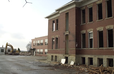
Final days for school in Willshire
Photo by Mark Pummell/The Daily Standard

The aging Willshire school building that housed Parkway Local School District's Middle School is now being demolished as the final phase in this year's three-part dismantling project of the Rockford, Mendon and Willshire school buildings. The approximately $1 million that it took to tear down the buildings was picked up by the Ohio State Facilities Commission (OSCF) as part of the $36 construction project of the new PreK-12 education complex located at the south edge of Rockford. The bell tower of the historic Willshire building is being salvaged with the property to be reverted back to the village of Willshire. In Mendon, residents hope to construct a community building on the newly razed grounds that now belong to the village. In Rockford, the old school property remains part of the new 40-acre plus school site.


Additional pictures on this date