Severe Thunderstorm Watch issued June 11 at 11:46PM EDT until June 12 at 3:00AM EDT by NWS Wilmington OH (details ...)
SEVERE THUNDERSTORM WATCH 319 REMAINS VALID UNTIL 3 AM EDT FRIDAY FOR THE FOLLOWING AREAS
IN INDIANA THIS WATCH INCLUDES 4 COUNTIES
IN EAST CENTRAL INDIANA
FAYETTE UNION WAYNE
IN SOUTHEAST INDIANA
FRANKLIN
IN OHIO THIS WATCH INCLUDES 16 COUNTIES
IN CENTRAL OHIO
MADISON UNION
IN SOUTHWEST OHIO
BUTLER WARREN
IN WEST CENTRAL OHIO
AUGLAIZE CHAMPAIGN CLARK DARKE GREENE HARDIN LOGAN MERCER MIAMI MONTGOMERY PREBLE SHELBY
THIS INCLUDES THE CITIES OF ADA, BEAVERCREEK, BELLEFONTAINE, BROOKVILLE, CAMDEN, CELINA, COLDWATER, CONNERSVILLE, DOWNTOWN DAYTON, EATON, FAIRBORN, FAIRFIELD, FRANKLIN, GREENVILLE, HAMILTON, KENTON, KETTERING, LANDEN, LEBANON, LIBERTY, LONDON, MARYSVILLE, MASON, MIDDLETOWN, MINSTER, NEW BREMEN, OXFORD, PIQUA, PLAIN CITY, RICHMOND, SIDNEY, SPRINGBORO, SPRINGFIELD, ST. MARYS, TIPP CITY, TROY, URBANA, WAPAKONETA, WEST COLLEGE CORNER, WEST JEFFERSON, AND XENIA.
68° 68° slight chance likely Fri 80° Fri 80° chance 61° 61° Sat 85° Sat 85°
Friday, January 19th, 2007
Swans enjoy local flooding
Photo by Mark Pummell/The Daily Standard

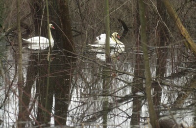
A pair of swans float through floodwater in a wooded area at the end of Anderson Road near the Mercer County Sportsman Club earlier this week. The rain has finally stopped and with cold temperatures has given way to snow flurries instead. A low of 17 degrees is predicted tonight and tomorrow will be breezy and cloudy with a high of 28 degrees.

Additional pictures on this date