Special Weather Statement issued January 27 at 8:22AM EST by NWS Wilmington OH (details ...)
Gusty southwest winds will become westerly this afternoon. The strong winds and the recently fallen snow is resulting in some blowing and drifting snow, especially across rural and open areas. This may result in rapid changes in road conditions over short distances. Motorists should exercise extra caution.
Cold Weather Advisory issued January 27 at 2:29AM EST until January 28 at 12:00PM EST by NWS Wilmington OH (details ...)
* WHAT...For the Extreme Cold Warning, dangerously cold wind chills as low as 25 below zero. For the Cold Weather Advisory, very cold wind chills as low as 20 below zero expected. * WHERE...Portions of east central and southeast Indiana, northeast and northern Kentucky, and central, south central, southwest, and west central Ohio. * WHEN...For the Extreme Cold Warning, until noon EST today. For the Cold Weather Advisory, from 7 PM this evening to noon EST Wednesday. * IMPACTS...Dangerously cold wind chills as low as 20 below zero could cause frostbite on exposed skin in as little as 30 minutes.
Extreme Cold Warning issued January 27 at 2:29AM EST until January 27 at 12:00PM EST by NWS Wilmington OH (details ...)
* WHAT...For the Extreme Cold Warning, dangerously cold wind chills as low as 25 below zero. For the Cold Weather Advisory, very cold wind chills as low as 20 below zero expected. * WHERE...Portions of east central and southeast Indiana, northeast and northern Kentucky, and central, south central, southwest, and west central Ohio. * WHEN...For the Extreme Cold Warning, until noon EST today. For the Cold Weather Advisory, from 7 PM this evening to noon EST Wednesday. * IMPACTS...Dangerously cold wind chills as low as 20 below zero could cause frostbite on exposed skin in as little as 30 minutes.
Wednesday, March 7th, 2007
Here we go again
Photo by Shelley Grieshop/The Daily Standard
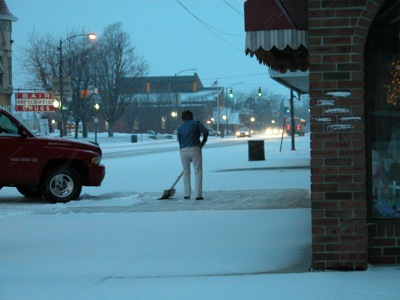
A Main Street merchant in Celina shovels snow that fell early this morning throughout the Grand Lake area. The white stuff was predicted to end by midday today with a high of 33. A warm-up is on the way with temperatures slowly rising from a high of 38 on Thursday to 48 on Sunday, according to local weather forecaster Dennis Howick. Rain also is predicted for at least a portion of the weekend, beginning Saturday.