Special Weather Statement issued May 1 at 12:13PM EDT by NWS Wilmington OH (details ...)
At 1212 PM EDT, a strong thunderstorm was located near New Bremen, moving northeast at 50 mph.
HAZARD...Wind gusts up to 45 mph and pea size hail.
SOURCE...Radar indicated.
IMPACT...Gusty winds could knock down tree limbs and blow around unsecured objects. Hail may cause minor damage to vegetation.
Locations impacted include... Newport, Fryburg, Montra, Egypt, Uniopolis, New Bremen, Buckland, Botkins, New Knoxville, Fort Loramie, Kettlersville, Moulton, Jackson Center, St. Marys, Anna, Kossuth, Lakeview, Lake Loramie State Park, Waynesfield, and Wapakoneta.
This includes I-75 in Ohio between mile markers 96 and 118.
If outdoors, consider seeking shelter inside a sturdy building.
To report hazardous weather conditions, go to our website at weather.gov/iln and submit your report via social media, when you can do so safely.
Today 74° Today 74° 58° 58° chance Tomorrow 71° Tomorrow 71° chance 54° 54° chance
Thursday, March 8th, 2007
Here it comes...
Photo by Shelley Grieshop/The Daily Standard

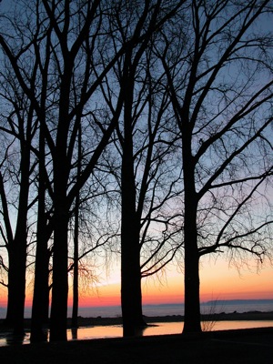
The rising sun creates a beautiful orange glow behind a row of tall trees along West Bank State Park in Celina this morning. Although today's high will remain in the 30s, Friday will seem like a heat wave as the temperature rises to 50. Less than a half-inch of rain is expected after midnight Friday into Saturday. A high of 48 is expected throughout the weekend. Warmer temperatures will continue with temperatures in the Grand Lake area reaching 55 by Wednesday, according to local weather forecaster Dennis Howick.

Additional pictures on this date