Special Weather Statement issued July 27 at 12:36PM EDT by NWS Wilmington OH (details ...)
At 1236 PM EDT, a strong thunderstorm was located near St. Marys, moving southeast at 25 mph.
HAZARD...Wind gusts up to 50 mph.
SOURCE...Radar indicated.
IMPACT...Gusty winds could knock down tree limbs and blow around unsecured objects.
Locations impacted include... St. Marys, New Bremen, Minster, Newport, Anna, Fort Loramie, Botkins, New Knoxville, Moulton, Chickasaw, Kettlersville, Montezuma, Egypt, Lake Loramie State Park, Maria Stein, Carthagena, Bulkhead, Mccartyville, and Houston.
This includes I-75 in Ohio between mile markers 101 and 107.
If outdoors, consider seeking shelter inside a sturdy building.
To report hazardous weather conditions, go to our website at weather.gov/iln and submit your report via social media, when you can do so safely.
Today 86° Today 86° likely 75° 75° chance Tomorrow 89° Tomorrow 89° slight chance 76° 76° slight chance
Tuesday, April 3rd, 2007
Photo by Mark Pummell/The Daily Standard

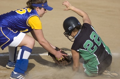
Celina's Amy Harner, right, slides safely into home plate during the Bulldogs' game against Findlay on Monday afternoon. Celina ran its record to 7-0 following an 8-3 win over the Trojans.

Additional pictures on this date