Winter Storm Warning issued January 24 at 1:49PM EST until January 26 at 12:00PM EST by NWS Wilmington OH (details ...)
* WHAT...Heavy snow. Snow accumulations between 9 and 11 inches.
* WHERE...Auglaize, Darke, Hardin, Logan, Mercer, and Shelby Counties.
* WHEN...Until noon EST Monday.
* IMPACTS...Travel could be very difficult. The hazardous conditions could impact the Monday morning commute.
Cold Weather Advisory issued January 24 at 1:32PM EST until January 26 at 6:00PM EST by NWS Wilmington OH (details ...)
* WHAT...For the Cold Weather Advisory, very cold wind chills as low as around 15 below zero expected. For the Extreme Cold Watch, dangerously cold wind chills as low as around 25 below zero possible.
* WHERE...Portions of east central and southeast Indiana, northeast and northern Kentucky, and central, south central, southwest, and west central Ohio.
* WHEN...For the Cold Weather Advisory, from midnight Sunday Night to 6 PM EST Monday. For the Extreme Cold Watch, from Monday evening through Tuesday morning.
* IMPACTS...The dangerously cold wind chills could cause frostbite on exposed skin in as little as 30 minutes.
Extreme Cold Watch issued January 24 at 1:32PM EST until January 27 at 12:00PM EST by NWS Wilmington OH (details ...)
* WHAT...For the Cold Weather Advisory, very cold wind chills as low as around 15 below zero expected. For the Extreme Cold Watch, dangerously cold wind chills as low as around 25 below zero possible.
* WHERE...Portions of east central and southeast Indiana, northeast and northern Kentucky, and central, south central, southwest, and west central Ohio.
* WHEN...For the Cold Weather Advisory, from midnight Sunday Night to 6 PM EST Monday. For the Extreme Cold Watch, from Monday evening through Tuesday morning.
* IMPACTS...The dangerously cold wind chills could cause frostbite on exposed skin in as little as 30 minutes.
Today 11° Today 11° slight chance Tomorrow 15° Tomorrow 15° heavy heavy
Thursday, April 26th, 2007
Chilly, wet walk
Photo by Shelley Grieshop/The Daily Standard

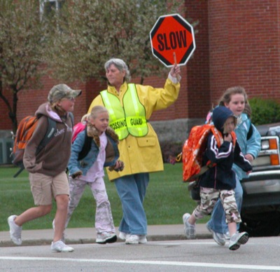
Alberta Siegrist, a St. Henry village employee, is dressed in yellow rain gear Wednesday as she helps a group of young students across the street at the intersection of Main and Walnut streets in the village. Thunderstorms, some possibly severe, were forecast for today with lingering showers in the area on Friday, according to the National Weather Service. Highs today will range in the mid- to upper-60s, 58 on Friday, 60 on Saturday and a warm and sunny 71 on Sunday, the NWS reported.

Additional pictures on this date