Frost Advisory issued April 5 at 1:22PM EDT until April 6 at 10:00AM EDT by NWS Wilmington OH (details ...)
* WHAT...For the Frost Advisory, temperatures as low as 34 will result in frost formation. For the Freeze Watch, sub-freezing temperatures as low as 27 possible.
* WHERE...Portions of east central and southeast Indiana and central, south central, southwest, and west central Ohio.
* WHEN...For the Frost Advisory, from 1 AM to 10 AM EDT Monday. For the Freeze Watch, from late Monday night through Tuesday morning.
* IMPACTS...Frost and freeze conditions could kill crops, other sensitive vegetation and possibly damage unprotected outdoor plumbing. Frost could harm sensitive outdoor vegetation. Sensitive outdoor plants may be killed if left uncovered.
Freeze Watch issued April 5 at 1:22PM EDT until April 7 at 10:00AM EDT by NWS Wilmington OH (details ...)
* WHAT...For the Frost Advisory, temperatures as low as 34 will result in frost formation. For the Freeze Watch, sub-freezing temperatures as low as 27 possible.
* WHERE...Portions of east central and southeast Indiana and central, south central, southwest, and west central Ohio.
* WHEN...For the Frost Advisory, from 1 AM to 10 AM EDT Monday. For the Freeze Watch, from late Monday night through Tuesday morning.
* IMPACTS...Frost and freeze conditions could kill crops, other sensitive vegetation and possibly damage unprotected outdoor plumbing. Frost could harm sensitive outdoor vegetation. Sensitive outdoor plants may be killed if left uncovered.
Today 46° Today 46° 36° 36° frost Tomorrow 50° Tomorrow 50° 25° 25°
Monday, December 3rd, 2007
Photo by Janie Southard/The Daily Standard

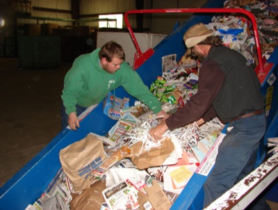
Rob Egbert of New Knoxville, left, and Kevin Sawmiller of St. Marys empty a hopper of mixed paper at the Auglaize County Recycling Center in St. Marys. The paper travels up the county's new baler and then is compacted into 1,500-pound bales. Supervisor Geno Gannon of Wapakoneta, right, makes sure the operation works smoothly.

Additional pictures on this date