Flood Watch issued August 11 at 7:04PM EDT until August 12 at 8:00AM EDT by NWS Wilmington OH (details ...)
* WHAT...Flash flooding caused by excessive rainfall continues to be possible.
* WHERE...The following counties, in Indiana, Dearborn, Fayette IN, Franklin IN, Ohio, Ripley, Switzerland, Union IN and Wayne, the following counties, in Kentucky, Boone, Bracken, Campbell, Carroll, Gallatin, Grant, Kenton, Lewis, Mason, Owen, Pendleton and Robertson, and the following counties, in Ohio, Adams, Auglaize, Brown, Butler, Champaign, Clark, Clermont, Clinton, Darke, Delaware, Fairfield, Fayette OH, Franklin OH, Greene, Hamilton, Hardin, Highland, Hocking, Licking, Logan, Madison, Mercer, Miami, Montgomery, Pickaway, Pike, Preble, Ross, Scioto, Shelby, Union OH and Warren.
* WHEN...Through Wednesday morning.
* IMPACTS...Excessive runoff may result in flooding of rivers, creeks, streams, and other low-lying and flood-prone locations.
* ADDITIONAL DETAILS... - Additional thunderstorms are expected into Wednesday morning. Locally heavy rainfall and the potential for storms to repeatedly track over the same areas are possible. This will result in the potential for flash flooding.
66° 66° chance Wed 83° Wed 83° chance 66° 66° chance Thu 82° Thu 82° likely
Monday, January 21st, 2008
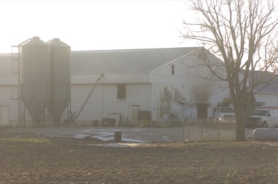
Photo by Mark Pummell/The Daily Standard

A large poultry barn at the farm of Bill Stachler, 1726 Fleetfoot Road, St. Henry, shows signs of damage following a Sunday afternoon fire that claimed 15,000 chickens. The heaviest damage was contained to an electrical area at the front of the building. No dollar loss has been set as yet.


Additional pictures on this date