Severe Thunderstorm Watch issued March 31 at 6:02PM EDT until April 1 at 12:00AM EDT by NWS Wilmington OH (details ...)
THE NATIONAL WEATHER SERVICE HAS ISSUED SEVERE THUNDERSTORM WATCH 82 IN EFFECT UNTIL MIDNIGHT EDT TONIGHT FOR THE FOLLOWING AREAS
IN OHIO THIS WATCH INCLUDES 3 COUNTIES
IN WEST CENTRAL OHIO
AUGLAIZE HARDIN MERCER
THIS INCLUDES THE CITIES OF ADA, CELINA, COLDWATER, KENTON, MINSTER, NEW BREMEN, ST. MARYS, AND WAPAKONETA.
Today 78° Today 78° chance 52° 52° chance Tomorrow 60° Tomorrow 60° 47° 47° likely
Wednesday, July 16th, 2008
Photo by Margie Wuebker/The Daily Standard

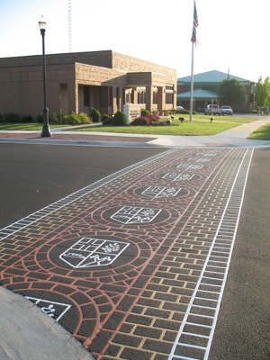
New Duratherm crosswalks bearing the distinctive Minster crest now decorate the intersection of Fourth and Hanover streets near the village administration building. The crest also will be used on street signs to be posted along reconstructed Hanover Street. The example shown to councilors Tuesday night bears the name Minster but the finished product will have the street name in a color yet to be selected.

Additional pictures on this date