Severe Thunderstorm Watch issued June 6 at 6:41PM EDT until June 6 at 10:00PM EDT by NWS Wilmington OH (details ...)
SEVERE THUNDERSTORM WATCH 279 REMAINS VALID UNTIL 10 PM EDT THIS EVENING FOR THE FOLLOWING AREAS
IN INDIANA THIS WATCH INCLUDES 4 COUNTIES
IN EAST CENTRAL INDIANA
FAYETTE IN UNION IN WAYNE
IN SOUTHEAST INDIANA
FRANKLIN IN
IN OHIO THIS WATCH INCLUDES 26 COUNTIES
IN CENTRAL OHIO
DELAWARE FAIRFIELD FAYETTE OH FRANKLIN OH HOCKING LICKING MADISON PICKAWAY UNION OH
IN SOUTH CENTRAL OHIO
HIGHLAND PIKE ROSS
IN SOUTHWEST OHIO
BUTLER CLINTON WARREN
IN WEST CENTRAL OHIO
AUGLAIZE CHAMPAIGN CLARK DARKE GREENE LOGAN MERCER MIAMI MONTGOMERY PREBLE SHELBY
THIS INCLUDES THE CITIES OF BEAVERCREEK, BELLEFONTAINE, BLANCHESTER, BROOKVILLE, CAMDEN, CELINA, CHILLICOTHE, CIRCLEVILLE, COLDWATER, COLUMBUS, CONNERSVILLE, DAYTON, DELAWARE, EATON, FAIRBORN, FAIRFIELD, GREENFIELD, GREENVILLE, HAMILTON, HILLSBORO, KETTERING, LANCASTER, LEBANON, LIBERTY, LOGAN, LONDON, MARYSVILLE, MASON, MIDDLETOWN, NEWARK, OXFORD, PICKERINGTON, PIKE LAKE, PIKETON, PIQUA, PLAIN CITY, RICHMOND, SIDNEY, SPRINGBORO, SPRINGFIELD, ST. MARYS, TIPP CITY, TROY, URBANA, WAPAKONETA, WASHINGTON COURT HOUSE, WAVERLY, WEST COLLEGE CORNER, WEST JEFFERSON, WILMINGTON, AND XENIA.
Today 82° Today 82° likely 67° 67° slight chance Tomorrow 81° Tomorrow 81° slight chance 67° 67° slight chance
Wednesday, October 15th, 2008
Ready for the 'S' word
Photo by Mark Pummell/The Daily Standard

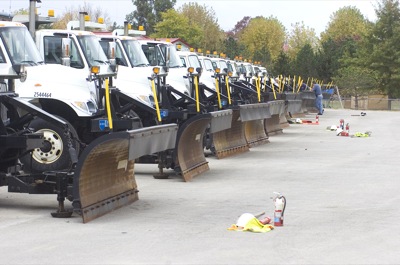
Trucks from the Ohio Department of Transportation (ODOT) post west of Celina are in the process of being "winterized," as equipment from inside each is emptied onto the pavement. Fine tuning of snow and ice removal equipment and testing, known as Operational Readiness, takes place in October and November at ODOT posts throughout Ohio. The statewide agency also implemented a Smart Salt Strategy campaign to remind motorists to take it slow in ice and snow as the department becomes more efficient with salt due to the high cost this year.

Additional pictures on this date