Winter Storm Watch issued January 22 at 1:34PM EST until January 26 at 1:00AM EST by NWS Wilmington OH (details ...)
* WHAT...Heavy snow possible. Total snow accumulations between 4 and 7 inches possible.
* WHERE...Auglaize, Darke, Hardin, Logan, Mercer, and Shelby Counties.
* WHEN...From Saturday morning through late Sunday night.
* IMPACTS...Travel could be very difficult.
Cold Weather Advisory issued January 22 at 12:34PM EST until January 23 at 12:00PM EST by NWS Wilmington OH (details ...)
* WHAT...Very cold wind chills as low as 13 below zero expected.
* WHERE...In Indiana, Wayne County. In Ohio, Auglaize, Darke, Hardin, Logan, Mercer, and Shelby Counties.
* WHEN...From 6 AM to noon EST Friday.
* IMPACTS...Wind chill values can lead to hypothermia with prolonged exposure.
* ADDITIONAL DETAILS...While temperatures are expected to be in the upper single digits (above zero), a northwest wind at 10-15 mph will make temperatures feel as if they are colder than 10 below zero.
Fri 10° Fri 10° -1° -1° Sat 11° Sat 11° chance
Monday, January 12th, 2009
Move that snow
Photo by Mark Pummell/The Daily Standard

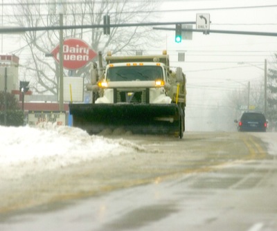
An Ohio Department Of Transportation (ODOT) snowplow clears snow from the intersection of Enterprise Street and state Route 29 in Celina on Saturday afternoon. The Grand Lake area received more than three inches of snow over the weekend. More snow is predicted tonight and tomorrow said local weather forecaster Dennis Howick from his Celina farm.

Additional pictures on this date