Winter Storm Watch issued January 22 at 1:34PM EST until January 26 at 1:00AM EST by NWS Wilmington OH (details ...)
* WHAT...Heavy snow possible. Total snow accumulations between 4 and 7 inches possible.
* WHERE...Auglaize, Darke, Hardin, Logan, Mercer, and Shelby Counties.
* WHEN...From Saturday morning through late Sunday night.
* IMPACTS...Travel could be very difficult.
Cold Weather Advisory issued January 22 at 12:34PM EST until January 23 at 12:00PM EST by NWS Wilmington OH (details ...)
* WHAT...Very cold wind chills as low as 13 below zero expected.
* WHERE...In Indiana, Wayne County. In Ohio, Auglaize, Darke, Hardin, Logan, Mercer, and Shelby Counties.
* WHEN...From 6 AM to noon EST Friday.
* IMPACTS...Wind chill values can lead to hypothermia with prolonged exposure.
* ADDITIONAL DETAILS...While temperatures are expected to be in the upper single digits (above zero), a northwest wind at 10-15 mph will make temperatures feel as if they are colder than 10 below zero.
Today 27° Today 27° Tomorrow Tomorrow -1° -1°
Monday, January 19th, 2009
Photo by Shelley Grieshop/The Daily Standard

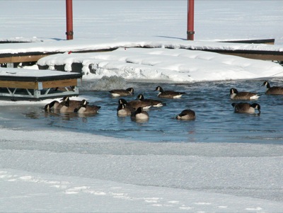
A flock of Canada geese make themselves at home near a water aeration system that is keeping open a section of the frozen lake along West Bank Road in Celina. The high temperature today will be in the lower 20s with an overnight low of 3; the windchill could make it feel like 8 below, according to the National Weather Service. Tuesdays high will be 23 with a windchill as low as minus 12 and an overnight low of 9. Snow flurries are expected both days.

Additional pictures on this date