Special Weather Statement issued January 19 at 4:06AM EST by NWS Wilmington OH (details ...)
An Arctic front will sweep east across the region between 5 AM and 9 AM. A few hours of snow showers and west wind gusts of 35 to 40 mph will occur with the frontal passage. While any accumulations will generally be a half inch or less, some challenging travel conditions may develop given, rapidly changing road conditions and visibilities, strong wind and cold temperatures. These conditions will impact the morning commute. Use caution and allow for extra time to reach your destination.
Cold Weather Advisory issued January 19 at 12:14AM EST until January 20 at 10:00AM EST by NWS Wilmington OH (details ...)
* WHAT...Very cold wind chills as low as 15 below zero expected.
* WHERE...Portions of east central Indiana and central and west central Ohio.
* WHEN...From 7 AM this morning to 10 AM EST Tuesday.
* IMPACTS...The cold wind chills could result in hypothermia if precautions are not taken. Wind chill values can lead to hypothermia with prolonged exposure.
light Mon 17° Mon 17° chance Tue 19° Tue 19°
Friday, May 1st, 2009
An unwanted waterfall
Photo by Mark Pummell/The Daily Standard

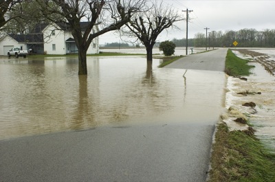
Some county residents are battling high water following Thursday night's rain, which some farmers' rain gauges measured at 3 to 4 inches. Several roads were closed this morning, according to the Mercer County Sheriff's Office, because of up to 3 feet of water over the roadway. Closed were: Gause Road between Swamp and St. Anthony roads; Karch Road between Kuhn and Monroe roads; and Kuhn Road between Karch and Burkettsville-St. Henry roads. Additionally, there was free flowing water running across Oldtown Road between Riley and Harris roads. Above is the heavy rain-created waterfall on Monroe Road.

Additional pictures on this date