Flood Watch issued August 14 at 2:57PM EDT until August 16 at 8:00AM EDT by NWS Wilmington OH (details ...)
* WHAT...Flash flooding caused by excessive rainfall is possible.
* WHERE...Portions of Indiana, including the following counties, Fayette, Franklin, Union and Wayne and Ohio, including the following counties, Auglaize, Butler, Champaign, Clark, Clinton, Darke, Delaware, Fairfield, Fayette, Franklin, Greene, Hardin, Hocking, Licking, Logan, Madison, Mercer, Miami, Montgomery, Pickaway, Preble, Ross, Shelby, Union and Warren.
* WHEN...From Saturday afternoon through Sunday morning.
* IMPACTS...Excessive runoff may result in flooding of rivers, creeks, streams, and other low-lying and flood-prone locations.
* ADDITIONAL DETAILS... - Another round of showers and thunderstorms is expected to move through the region Saturday into Saturday night. Given the saturated ground, additional heavy rainfall may result in flash flooding.
67° 67° Sat 84° Sat 84° slight chance likely 72° 72° likely Sun 86° Sun 86° chance
Tuesday, July 7th, 2009
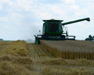
Local wheat harvest
Photo by Shelley Grieshop/The Daily Standard

A farmer combines wheat in a field along Siegrist-Jutte Road in rural Coldwater Monday afternoon. A cool May helped the state's crop this year and farmers can expect strong yields and high quality information from the OSU Extension states. Mercer County farmers are reporting yields ranging from 60 to 100 bushels per acre, said Chris Gibbs of the Mercer County Farm Service Agency. The average county yield is 70 to 73 bushels per acre. The first of the county's wheat started coming off the last weekend of June and the harvest began in earnest Monday, Gibbs said. Monday's weather was near perfect for outside work with sunny skies and a high temperature of 82. Today's forecast should be a near repeat of Monday, said local weather forecaster Dennis Howick.


Additional pictures on this date