Special Weather Statement issued October 21 at 4:34PM EDT by NWS Wilmington OH (details ...)
At 434 PM EDT, strong thunderstorms were located along a line extending from near Delphos to near Versailles, moving east at 40 mph.
HAZARD...Wind gusts up to 45 mph.
SOURCE...Radar indicated.
IMPACT...Gusty winds could knock down tree limbs and blow around unsecured objects.
Locations impacted include... Sidney, Wapakoneta, St. Marys, Ada, Fort Shawnee, New Bremen, Minster, Newport, Cridersville, Anna, Fort Loramie, Jackson Center, Russells Point, De Graff, Botkins, Lakeview, New Knoxville, Alger, Waynesfield, and Chippewa Park.
This includes I-75 in Ohio between mile markers 91 and 118.
If outdoors, consider seeking shelter inside a sturdy building.
To report hazardous weather conditions, go to our website at weather.gov/iln and submit your report via social media, when you can do so safely.
Today 63° Today 63° chance 42° 42° slight chance Tomorrow 54° Tomorrow 54° slight chance 38° 38° slight chance
Friday, December 4th, 2009
Photo by Shelley Grieshop/The Daily Standard

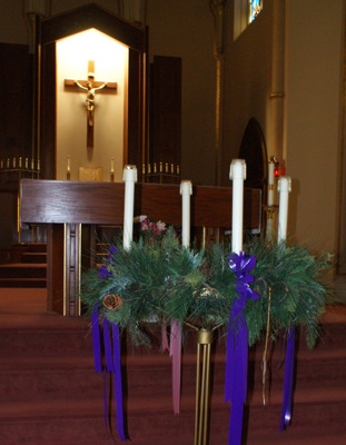
Pictured in front of the altar inside Holy Trinity Catholic Church in Coldwater is a large Advent wreath and candles - a symbol of the coming of Jesus at Christmas. On Sunday, the first Advent candle was lit. The local church this year is using four white candles adorned with purple and pink ribbons instead of the more traditional three purple candles and a pink one.

Additional pictures on this date