Flood Watch issued August 10 at 1:04PM EDT until August 12 at 8:00AM EDT by NWS Wilmington OH (details ...)
* WHAT...Flash flooding caused by excessive rainfall is possible.
* WHERE...Portions of Indiana, including the following counties, Dearborn, Fayette, Franklin, Union and Wayne, Kentucky, including the following counties, Boone, Bracken, Campbell, Kenton, Lewis, Mason, Pendleton and Robertson, and Ohio, including the following counties, Adams, Auglaize, Brown, Butler, Champaign, Clark, Clermont, Clinton, Darke, Delaware, Fairfield, Fayette, Franklin, Greene, Hamilton, Hardin, Highland, Hocking, Licking, Logan, Madison, Mercer, Miami, Montgomery, Pickaway, Pike, Preble, Ross, Scioto, Shelby, Union and Warren.
* WHEN...Through Wednesday morning.
* IMPACTS...Excessive runoff may result in flooding of rivers, creeks, streams, and other low-lying and flood-prone locations.
* ADDITIONAL DETAILS... - Several rounds of thunderstorms are expected through Tuesday night. Locally heavy rainfall can be expected with the potential for storms to repeatedly track over the same locations. This will result in the potential for flash flooding.
Today 84° Today 84° chance 68° 68° chance likely Tomorrow 82° Tomorrow 82° likely chance 67° 67° chance
Saturday, January 9th, 2010
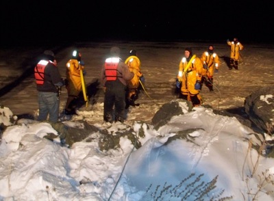
Practicing a rescue
Submitted Photo

Members of the St. Marys Township Fire Department and deputies trained for ice rescues this week on the east bank of Grand Lake. Fire Chief Chad Hicks says the department is periodically called out this time of year for animals and people who venture out onto the ice and fall through. Firefighters were surprised to find the lake unsafe and dangerous with numerous open water areas remaining unfrozen, despite temperatures being at or below freezing for weeks. Firefighters fell through the ice several times at weak spots - some as far as 300 feet from shore, Hicks said.

Additional pictures on this date