Special Weather Statement issued May 1 at 12:13PM EDT by NWS Wilmington OH (details ...)
At 1212 PM EDT, a strong thunderstorm was located near New Bremen, moving northeast at 50 mph.
HAZARD...Wind gusts up to 45 mph and pea size hail.
SOURCE...Radar indicated.
IMPACT...Gusty winds could knock down tree limbs and blow around unsecured objects. Hail may cause minor damage to vegetation.
Locations impacted include... Newport, Fryburg, Montra, Egypt, Uniopolis, New Bremen, Buckland, Botkins, New Knoxville, Fort Loramie, Kettlersville, Moulton, Jackson Center, St. Marys, Anna, Kossuth, Lakeview, Lake Loramie State Park, Waynesfield, and Wapakoneta.
This includes I-75 in Ohio between mile markers 96 and 118.
If outdoors, consider seeking shelter inside a sturdy building.
To report hazardous weather conditions, go to our website at weather.gov/iln and submit your report via social media, when you can do so safely.
Today 74° Today 74° 58° 58° chance Tomorrow 71° Tomorrow 71° chance 54° 54° chance
Saturday, February 6th, 2010
Not what it seems
Photo by Mark Pummell/The Daily Standard

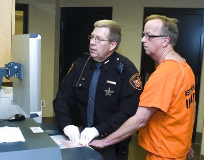
Mercer County Corrections Officer Barry Fennig fingerprints Dan Uhlenhake, of Celina, who was booked into the new Mercer County Adult Detention Center Friday night as one of first 32 "practice" inmates. The exercise, which will be repeated one more time before "real" inmates show up Feb. 28, is designed to help corrections officers become accustomed to operation of the facility. Daily Standard reporter Margie Wuebker is among those spending 24 hours there. Her story and photos will appear Monday.

Additional pictures on this date