Special Weather Statement issued June 25 at 3:57PM EDT by NWS Wilmington OH (details ...)
At 357 PM EDT, a strong thunderstorm was located near Fort Recovery, moving southeast at 35 mph.
HAZARD...Wind gusts up to 40 mph and very heavy rain.
SOURCE...Radar indicated.
IMPACT...Gusty winds could knock down tree limbs and blow around unsecured objects. Visibility will be poor and hydroplaning is possible.
Locations impacted include... Greenville, Versailles, Fort Recovery, Ansonia, Burkettsville, North Star, Rossburg, New Weston, Darke County Airport, North Dayton, Rose Hill, Cosmos, Brock, State Route 47 at US Route 127, Eldora Speedway, Willowdell, and Pikeville.
If outdoors, consider seeking shelter inside a sturdy building.
Motorists should slow down and use extra caution.
To report hazardous weather conditions, go to our website at weather.gov/iln and submit your report via social media, when you can do so safely.
Today 80° Today 80° chance slight chance 64° 64° Tomorrow 75° Tomorrow 75° 66° 66°
Saturday, February 20th, 2010
Overflow
Photo by Nancy Allen/The Daily Standard

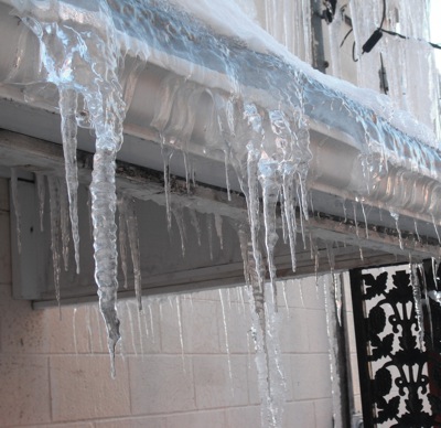
Icicles hang from the roof of a building next to The Daily Standard Friday as accumulated snow has begun to melt and form the glistening objects. It will continue to warm during the day but drop below freezing tonight and Sunday night.

Additional pictures on this date