Flood Warning issued September 17 at 4:22PM EDT until September 17 at 10:45PM EDT by NWS Wilmington OH (details ...)
* WHAT...Flooding caused by excessive rainfall continues.
* WHERE...Northwestern Auglaize County in west central Ohio... Mercer County in west central Ohio...
* WHEN...Until 1045 PM EDT Thursday.
* IMPACTS...Flooding of rivers, creeks, streams, and other low-lying and flood-prone locations is imminent or occurring. Numerous roads remain closed due to flooding. Expect many areas of slow moving or standing water.
* ADDITIONAL DETAILS... - At 421 PM EDT, local law enforcement reported flooding in the warned area, with numerous roads remaining closed due to high water. Between 2.5 and 3.5 inches of rain have fallen. Flooding impacts will continue, but no additional rainfall is expected. - Some locations that may experience flooding include... Celina, St. Marys, Coldwater, New Bremen, Rockford, Wabash, Mendon, Chickasaw, Montezuma, Tama, Neptune, Carthagena, Bulkhead, State Route 116 at State Route 197, Chattanooga and Kossuth.
65° 65° chance Fri 77° Fri 77° 60° 60° Sat 78° Sat 78° likely
Saturday, July 9th, 2011
Photo by Janie Southard/The Daily Standard

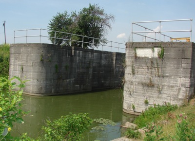
Part of Grand Lake's East Bank bulkhead still stands facing the Miami and Erie Canal feeder. The structure is now a two slide-gate system to the west of state Route 364.


Additional pictures on this date