Tornado Watch issued March 26 at 4:58PM EDT until March 26 at 11:00PM EDT by NWS Wilmington OH (details ...)
THE NATIONAL WEATHER SERVICE HAS ISSUED TORNADO WATCH 75 IN EFFECT UNTIL 11 PM EDT THIS EVENING FOR THE FOLLOWING AREAS
IN OHIO THIS WATCH INCLUDES 8 COUNTIES
IN CENTRAL OHIO
DELAWARE LICKING UNION OH
IN WEST CENTRAL OHIO
AUGLAIZE HARDIN LOGAN MERCER SHELBY
THIS INCLUDES THE CITIES OF ADA, BELLEFONTAINE, CELINA, COLDWATER, DELAWARE, KENTON, MARYSVILLE, NEWARK, SIDNEY, ST. MARYS, AND WAPAKONETA.
Today 75° Today 75° slight chance slight chance 35° 35° chance Tomorrow 44° Tomorrow 44° chance 26° 26°
Monday, December 5th, 2011
High water
Photo by Mark Pummell/The Daily Standard

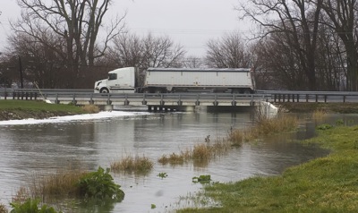
A semi crosses over the bridge on U.S. 127 this morning as flood water rises in Beaver Creek. Mercer County received 0.79 inches of rain Sunday and overnight, stated Dennis Howick, local weather forecaster. Mercer County EMA director Mike Robbins this morning said he doesn't expect any flooding on the roadways today. The National Weather Service is predicting another 1/2- to 3/4-inch of rain today. The remainder of the week is expected to be dry.

Additional pictures on this date