Flood Warning issued September 18 at 12:21AM EDT until September 18 at 8:00AM EDT by NWS Wilmington OH (details ...)
* WHAT...Flooding caused by excessive rainfall continues.
* WHERE...Northwestern Auglaize County in west central Ohio... Mercer County in west central Ohio...
* WHEN...Until 800 AM EDT Friday.
* IMPACTS...Numerous roads remain closed due to flooding. Expect many areas of slow moving or standing water.
* ADDITIONAL DETAILS... - At 1218 AM EDT, radar indicated scattered thunderstorms developing which contain moderate to heavy rainfall. Flooding is ongoing or expected to begin shortly in the warned area. Additional rainfall amounts of 0.5 to 1 inch are possible in the warned area over the next hour or two. - Some locations that may experience flooding include... Celina, St. Marys, Coldwater, New Bremen, Rockford, Wabash, Mendon, Chickasaw, Montezuma, Tama, Neptune, Carthagena, Bulkhead, State Route 116 at State Route 197, Chattanooga and Kossuth.
65° 65° chance Fri 77° Fri 77° 60° 60° Sat 78° Sat 78° likely
Thursday, March 15th, 2012
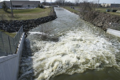
Opened spillway
Photo by Shelley Grieshop/The Daily Standard

Water rushes from Grand Lake into Beaver Creek via the West Bank spillway on Wednesday as area anglers dot the shoreline. A 60-inch tube at the base of the spillway was fully opened Monday to lower the lake level. The state initially opened the tube 40 inches on March 5 as part of a pilot study on lake level management to help prevent flooding downstream. The tube may stay open for several weeks as the study continues. A second tube below the spillway remains closed.


Additional pictures on this date