Flood Watch issued August 11 at 2:09AM EDT until August 12 at 8:00AM EDT by NWS Wilmington OH (details ...)
* WHAT...Flash flooding caused by excessive rainfall continues to be possible.
* WHERE...Portions of Indiana, including the following counties, Dearborn, Fayette, Franklin, Union and Wayne, Kentucky, including the following counties, Boone, Bracken, Campbell, Kenton, Lewis, Mason, Pendleton and Robertson, and Ohio, including the following counties, Adams, Auglaize, Brown, Butler, Champaign, Clark, Clermont, Clinton, Darke, Delaware, Fairfield, Fayette, Franklin, Greene, Hamilton, Hardin, Highland, Hocking, Licking, Logan, Madison, Mercer, Miami, Montgomery, Pickaway, Pike, Preble, Ross, Scioto, Shelby, Union and Warren.
* WHEN...Through Wednesday morning.
* IMPACTS...Excessive runoff may result in flooding of rivers, creeks, streams, and other low-lying and flood-prone locations.
* ADDITIONAL DETAILS... - Several rounds of thunderstorms are expected through Tuesday night. Locally heavy rainfall can be expected with the potential for storms to repeatedly track over the same locations. This will result in the potential for flash flooding.
69° 69° chance Tue 82° Tue 82° likely 66° 66° likely Wed 82° Wed 82° chance
Saturday, March 17th, 2012
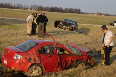
Two injured
Photo by Betty Lawrence/The Daily Standard

Two female drivers were injured on Friday evening after their vehicles collided at approximately 6:45 p.m. at the intersection of state Route 29 and Harris Road. The driver of the vehicle in the ditch was extracted by Celina firefighters using Jaws of Life equipment. Both drivers were injured and transported to Joint Township District Memorial Hospital, St. Marys, according to the Celina Fire Department. Both vehicles were heavily damaged. Additional information was unavailable Friday evening.


Additional pictures on this date