Flash Flood Warning issued September 17 at 8:26AM EDT until September 17 at 11:00AM EDT by NWS Wilmington OH (details ...)
FFWILN
The National Weather Service in Wilmington has extended the
* Flash Flood Warning for... Northwestern Auglaize County in west central Ohio... Mercer County in west central Ohio...
* Until 1100 AM EDT.
* At 826 AM EDT, radar indicated thunderstorms producing heavy rain across the warned area. Between 2 and 3 inches of rain have fallen. Additional rainfall amounts up to 0.5 inches are possible in the warned area. Flash flooding is ongoing or expected to begin shortly.
HAZARD...Flash flooding caused by thunderstorms.
SOURCE...Radar indicated.
IMPACT...Flash flooding of small creeks and streams, urban areas, highways, streets and underpasses as well as other poor drainage and low-lying areas.
* Some locations that may experience flash flooding include... Celina, St. Marys, Coldwater, New Bremen, Rockford, Wabash, Mendon, Chickasaw, Montezuma, Tama, Neptune, Carthagena, Bulkhead, State Route 116 at State Route 197, Chattanooga and Kossuth.
Flood Watch issued September 17 at 2:22AM EDT until September 17 at 2:00PM EDT by NWS Wilmington OH (details ...)
* WHAT...Flash flooding caused by excessive rainfall continues to be possible.
* WHERE...Portions of central and west central Ohio, including the following counties, in central Ohio, Delaware, Franklin, Licking, Madison and Union. In west central Ohio, Auglaize, Champaign, Clark, Darke, Hardin, Logan, Mercer, Miami and Shelby.
* WHEN...Until 2 PM EDT this afternoon.
* IMPACTS...Excessive runoff may result in flooding of rivers, creeks, streams, and other low-lying and flood-prone locations.
* ADDITIONAL DETAILS... - Multiple rounds of showers and thunderstorms will move across parts of the area this morning, possibly extending into early afternoon. This may result in bands of heavier rainfall that could lead to flash flooding.
Today 83° Today 83° likely 67° 67° slight chance chance Tomorrow 77° Tomorrow 77° 62° 62°
Thursday, June 28th, 2012

Firefighters keep field blaze from igniting buildings

By Margie Wuebker
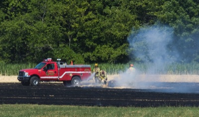
Photo by Mark Pummell/The Daily Standard

St. Henry firefighters work on a hot spot in a pile of straw along Siegrist-Jutte Road near Coldwater on Wednesday morning.

COLDWATER - Several homes and outbuildings were saved Wednesday morning thanks to the efforts of a local farmer and the quick response of area firefighters.
Coldwater-area farmer Rick Dues was baling wheat straw in a 30-acre field along the 3300 block of Siegrist-Jutte Road when he spotted a circle of fire in the stubble.
"I was clear on the other end of the field," Dues said. "The circle of fire appeared to be only 10 inches in diameter but everything is so dry."
The flames, fanned by a brisk breeze, quickly took off, consuming large round bales and the baler. Dark smoke blew toward nearby homes and storage buildings.
After placing a cell phone call to 911 at 9:43 a.m. and parking his tractor, Dues grabbed a shovel and began beating out flames heading in the direction of a barn with fenced-in livestock.
"I was afraid the homes and buildings might go," he said surveying the blackened field located behind two homes and outbuildings.
Coldwater, Southwest Mercer and St. Henry fire departments responded to the scene.
"I was afraid our shed would go with the riding lawnmower still inside," neighbor Donna Hemmelgarn said. "The flames came really close."
Dues said his loss is minimal compared to what might have happened.
"I expected to get at least 50 bales for my cattle," he said. "Now I will have to buy what I need."
Grass fire trucks traveled the field so firefighters could continue spraying water on possible hot spots.
"Without their efforts, this story would have ended differently," Dues said. "I expect a spark was all it took ... I don't remember such dry conditions since 1988."
The National Weather Service in Cleveland has issued a red flag warning for Northwest Ohio today through 8 p.m. With the likelihood of wind gusts up to 25 miles per hour, humidity as low as 23 to 27 percent and triple digit temperatures, a fire could get out of hand quickly.
The Ohio Department of Natural Resources' Division of Forestry recommends Ohioans avoid burning trash and debris, keep grass trimmed and refrain from discarding cigarettes and other smoking materials outside.
Chief state forester Robert Boyles said people also need to be vigilant with equipment that produces heat and sparks such as catalytic converters, hot mufflers, welding equipment and chainsaws.

Subscriber and paid stories on this date
Local agency offering air conditioners, assistance to those in need
Record-breaking heat is expected to bake the area today.
Local weather forecaster Dennis Howick said the record high temperature - 99 degrees on June 28, 1988 - likely will be broken with an expected high of 100 today.
FORT LORAMIE - Zac Brown Band, Blake Shelton and Eric Church are the headliners at this year's County Concert at Hickory Hill Lakes on July 5-7.
Th
WAPAKONETA - The Wapakoneta ACME baseball team got a four-hit shutout from pitcher Marshall Gerlach and the Redskins rolled to a 5-0 win over Coldwater on Wednesday.
Compiled by Gary R. Rasberry
Grand Lake was unable to hold a 1-0 lead as Licking County scored one run in the fifth inning and four more in the eighth for a 5-1 win over the Mariners on Wednesday night at Don Edwards Field in Newark.