Flood Watch issued September 17 at 2:22AM EDT until September 17 at 2:00PM EDT by NWS Wilmington OH (details ...)
* WHAT...Flash flooding caused by excessive rainfall continues to be possible.
* WHERE...Portions of central and west central Ohio, including the following counties, in central Ohio, Delaware, Franklin, Licking, Madison and Union. In west central Ohio, Auglaize, Champaign, Clark, Darke, Hardin, Logan, Mercer, Miami and Shelby.
* WHEN...Until 2 PM EDT this afternoon.
* IMPACTS...Excessive runoff may result in flooding of rivers, creeks, streams, and other low-lying and flood-prone locations.
* ADDITIONAL DETAILS... - Multiple rounds of showers and thunderstorms will move across parts of the area this morning, possibly extending into early afternoon. This may result in bands of heavier rainfall that could lead to flash flooding.
68° 68° chance Thu 84° Thu 84° likely 65° 65° slight chance Fri 77° Fri 77°
Friday, August 10th, 2012
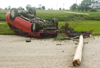
Accident damage
Photo by Mark Pummell/The Daily Standard

A 2001 Jeep SUV rests on its top following a Thursday night accident in the 3500 block of Mud Pike near Celina. Katie Clairetta Hague, 23, of Celina, was eastbound when she reportedly drove off the right side of the road shortly before 6 p.m. The vehicle drove several feet along a soybean field before striking a utility pole. Hague reportedly crawled from the vehicle and was treated at the scene but refused transport to a hospital. The heavily damaged SUV was towed from the scene.


Additional pictures on this date