Cold Weather Advisory issued January 18 at 7:21PM EST until January 20 at 9:00AM EST by NWS Wilmington OH (details ...)
* WHAT...Very cold wind chills as low as 12 below zero expected.
* WHERE...Portions of east central Indiana and central and west central Ohio.
* WHEN...From 7 AM Monday to 9 AM EST Tuesday.
* IMPACTS...The cold wind chills as low as 10 below zero could result in hypothermia if precautions are not taken. Wind chill values can lead to hypothermia with prolonged exposure.
Special Weather Statement issued January 18 at 7:17PM EST by NWS Wilmington OH (details ...)
Periods of light snow can be expected tonight with some scattered snow showers then lingering into Monday morning. Snow totals of around an inch or less will be possible. Increasing winds later tonight and Monday morning will support blowing snow, primarily in rural areas.
Challenging travel conditions will be possible starting tonight and continuing through the day on Monday. Use caution and allow for extra time to reach your destination.
light Mon 17° Mon 17° chance Tue 19° Tue 19°
Saturday, December 22nd, 2012
Accident
Photo by Mark Pummell/The Daily Standard

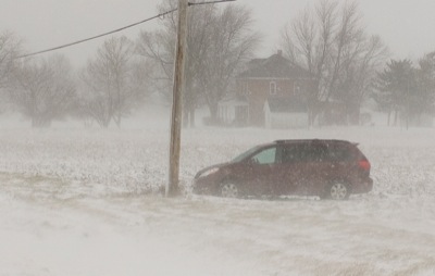
A minivan rests in a field south of Younger Road along U.S. 127 south of Celina on Friday after the driver lost control in nearly white-out conditions. The season's first weather event caused about 40 slide-offs in Mercer County, most of which were reported on U.S. 127, Mercer County Sheriff Office Chief Deputy Gery Thobe said Friday evening. The sheriff's department close a section of U.S. 127 and state Route 274 from 11:47 a.m. to 1:26 p.m. Friday due to several semitrailers being jack-knifed. No accidents or injuries were reported. Local weather forecaster Dennis Howick said the storm produced 0.7 inch of snow with high wind gusts.

Additional picture on this date