Special Weather Statement issued May 1 at 12:13PM EDT by NWS Wilmington OH (details ...)
At 1212 PM EDT, a strong thunderstorm was located near New Bremen, moving northeast at 50 mph.
HAZARD...Wind gusts up to 45 mph and pea size hail.
SOURCE...Radar indicated.
IMPACT...Gusty winds could knock down tree limbs and blow around unsecured objects. Hail may cause minor damage to vegetation.
Locations impacted include... Newport, Fryburg, Montra, Egypt, Uniopolis, New Bremen, Buckland, Botkins, New Knoxville, Fort Loramie, Kettlersville, Moulton, Jackson Center, St. Marys, Anna, Kossuth, Lakeview, Lake Loramie State Park, Waynesfield, and Wapakoneta.
This includes I-75 in Ohio between mile markers 96 and 118.
If outdoors, consider seeking shelter inside a sturdy building.
To report hazardous weather conditions, go to our website at weather.gov/iln and submit your report via social media, when you can do so safely.
Today 74° Today 74° 58° 58° chance Tomorrow 71° Tomorrow 71° chance 54° 54° chance
Saturday, February 16th, 2013
Photo by Daily Standard Staff

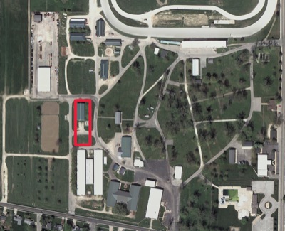
The Mercer County Fair Board hopes to build a $500,000 expo center north of the two cattle buildings and east of the horse arena at the fairgrounds. A pony barn would be razed.

Related online story:
CELINA - Plans for an expo center at the fairgrounds are growing and include a partnership with the local university.
Mercer County Fairgrounds Manager Cara Muhlenkamp said Wright State University-Lake Campus' agricultural program hopes to utilize the building as a training and educational center. [More]
Additional pictures on this date