Special Weather Statement issued May 1 at 12:13PM EDT by NWS Wilmington OH (details ...)
At 1212 PM EDT, a strong thunderstorm was located near New Bremen, moving northeast at 50 mph.
HAZARD...Wind gusts up to 45 mph and pea size hail.
SOURCE...Radar indicated.
IMPACT...Gusty winds could knock down tree limbs and blow around unsecured objects. Hail may cause minor damage to vegetation.
Locations impacted include... Newport, Fryburg, Montra, Egypt, Uniopolis, New Bremen, Buckland, Botkins, New Knoxville, Fort Loramie, Kettlersville, Moulton, Jackson Center, St. Marys, Anna, Kossuth, Lakeview, Lake Loramie State Park, Waynesfield, and Wapakoneta.
This includes I-75 in Ohio between mile markers 96 and 118.
If outdoors, consider seeking shelter inside a sturdy building.
To report hazardous weather conditions, go to our website at weather.gov/iln and submit your report via social media, when you can do so safely.
Today 74° Today 74° 58° 58° chance Tomorrow 71° Tomorrow 71° chance 54° 54° chance
Thursday, May 21st, 2015
Photo by Mark Pummell/The Daily Standard

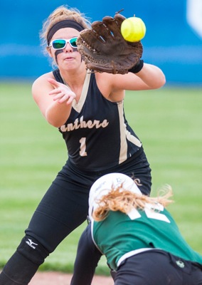
Parkway shortstop Alyx Slusher gets ready to put the tag on Tinora's Ashley Mack during the sixth inning of a Division III district semifinal softball game Wednesday night at Bath High School.

Related online story:
BATH TOWNSHIP - Parkway was having problems finding holes in Tinora's defense for the first five innings of Wednesday's Division III district semifinal. [More]
Additional pictures on this date