Tornado Watch issued May 7 at 6:01PM EDT until May 8 at 1:00AM EDT by NWS Wilmington OH (details ...)
THE NATIONAL WEATHER SERVICE HAS ISSUED TORNADO WATCH 197 IN EFFECT UNTIL 1 AM EDT WEDNESDAY FOR THE FOLLOWING AREAS
IN INDIANA THIS WATCH INCLUDES 8 COUNTIES
IN EAST CENTRAL INDIANA
FAYETTE UNION WAYNE
IN SOUTHEAST INDIANA
DEARBORN FRANKLIN OHIO RIPLEY SWITZERLAND
IN KENTUCKY THIS WATCH INCLUDES 12 COUNTIES
IN NORTHEAST KENTUCKY
LEWIS
IN NORTHERN KENTUCKY
BOONE BRACKEN CAMPBELL CARROLL GALLATIN GRANT KENTON MASON OWEN PENDLETON ROBERTSON
IN OHIO THIS WATCH INCLUDES 32 COUNTIES
IN CENTRAL OHIO
DELAWARE FAIRFIELD FAYETTE FRANKLIN HOCKING LICKING MADISON PICKAWAY UNION
IN SOUTH CENTRAL OHIO
ADAMS HIGHLAND PIKE ROSS SCIOTO
IN SOUTHWEST OHIO
BROWN BUTLER CLERMONT CLINTON HAMILTON WARREN
IN WEST CENTRAL OHIO
AUGLAIZE CHAMPAIGN CLARK DARKE GREENE HARDIN LOGAN MERCER MIAMI MONTGOMERY PREBLE SHELBY
THIS INCLUDES THE CITIES OF ABERDEEN, ADA, ALEXANDRIA, AUGUSTA, AURORA, BATESVILLE, BEAVERCREEK, BELLEFONTAINE, BELLEVUE, BLANCHESTER, BRIGHT, BROOKSVILLE, BROOKVILLE, BURLINGTON, BUTLER, CAMDEN, CAMP DIX, CARROLLTON, CELINA, CHILLICOTHE, CIRCLEVILLE, COLDWATER, CONNERSVILLE, COVINGTON, CRITTENDEN, DAY HEIGHTS, DAYTON, DELAWARE, DILLSBORO, DOWNTOWN CINCINNATI, DOWNTOWN COLUMBUS, DOWNTOWN DAYTON, DRY RIDGE, EATON, ERLANGER, FAIRBORN, FAIRFIELD, FALMOUTH, FLORENCE, FORT THOMAS, FRANKLIN, GEORGETOWN, GREENDALE, GREENFIELD, GREENVILLE, HAMILTON, HEAD OF GRASSY, HIDDEN VALLEY, HIGHLAND HEIGHTS, HILLSBORO, INDEPENDENCE, KENTON, KETTERING, LANCASTER, LANDEN, LAWRENCEBURG, LEBANON, LIBERTY, LOGAN, LONDON, MANCHESTER, MARYSVILLE, MASON, MAYSVILLE, MIDDLETOWN, MILAN, MILFORD, MINSTER, MOUNT CARMEL, MOUNT OLIVET, MOUNT ORAB, MOUNT REPOSE, MULBERRY, NEW BREMEN, NEWARK, NEWPORT, OAKBROOK, OSGOOD, OWENTON, OXFORD, PEEBLES, PICKERINGTON, PIKE LAKE, PIKETON, PIQUA, PLAIN CITY, PORTSMOUTH, RICHMOND, RIPLEY, RISING SUN, SEAMAN, SIDNEY, SPRINGBORO, SPRINGFIELD, ST. MARYS, SUMMERSIDE, TIPP CITY, TOLLESBORO, TROY, URBANA, VANCEBURG, VERSAILLES, VEVAY, WAPAKONETA, WARSAW, WASHINGTON COURT HOUSE, WAVERLY, WEST COLLEGE CORNER, WEST JEFFERSON, WEST UNION, WHEELERSBURG, WILLIAMSTOWN, WILMINGTON, WINCHESTER, WITHAMSVILLE, AND XENIA.
Tornado Warning issued May 7 at 8:56PM EDT until May 7 at 9:30PM EDT by NWS Wilmington OH (details ...)
TORILN
The National Weather Service in Wilmington has issued a
* Tornado Warning for... Northwestern Logan County in west central Ohio... Central Auglaize County in west central Ohio...
* Until 930 PM EDT.
* At 855 PM EDT, a severe thunderstorm capable of producing a tornado was located near Wapakoneta, moving east at 25 mph.
HAZARD...Tornado.
SOURCE...Radar indicated rotation.
IMPACT...Flying debris will be dangerous to those caught without shelter. Mobile homes will be damaged or destroyed. Damage to roofs, windows, and vehicles will occur. Tree damage is likely.
* Locations impacted include... Wapakoneta, Lakeview, Waynesfield, Uniopolis, Fryburg, New Hampshire, and St. Johns.
This includes I-75 in Ohio between mile markers 107 and 114.
59° 59° likely Wed 80° Wed 80° 57° 57° Thu 64° Thu 64°
Monday, November 2nd, 2015
Rollover crash
Photo by Doug Drexler/The Daily Standard

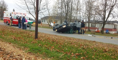
A 1997 Chevrolet pickup truck on Saturday afternoon rests upside down in the 3900 block of Mud Pike. Three people were reportedly in the vehicle at the time of the accident, according to the Mercer County Sheriff's office. One occupant, Olivia Birt, 14, Indianapolis, Ind., was ejected from the truck. Jamie Black, 17, and Kevin Dawson, 17, both of Celina, were also in the vehicle. A LifeFlight helicopter was reportedly called for medical transport. Medical conditions of the three were not released by the sheriff's office. The vehicle was reportedly traveling eastbound when the driver lost control after negotiating a curve and rolled over. A full report is pending from the sheriff's office.

Additional pictures on this date