Winter Storm Watch issued January 22 at 1:34PM EST until January 26 at 1:00AM EST by NWS Wilmington OH (details ...)
* WHAT...Heavy snow possible. Total snow accumulations between 4 and 7 inches possible.
* WHERE...Auglaize, Darke, Hardin, Logan, Mercer, and Shelby Counties.
* WHEN...From Saturday morning through late Sunday night.
* IMPACTS...Travel could be very difficult.
Cold Weather Advisory issued January 22 at 12:34PM EST until January 23 at 12:00PM EST by NWS Wilmington OH (details ...)
* WHAT...Very cold wind chills as low as 13 below zero expected.
* WHERE...In Indiana, Wayne County. In Ohio, Auglaize, Darke, Hardin, Logan, Mercer, and Shelby Counties.
* WHEN...From 6 AM to noon EST Friday.
* IMPACTS...Wind chill values can lead to hypothermia with prolonged exposure.
* ADDITIONAL DETAILS...While temperatures are expected to be in the upper single digits (above zero), a northwest wind at 10-15 mph will make temperatures feel as if they are colder than 10 below zero.
Today 27° Today 27° Tomorrow Tomorrow -1° -1°
Wednesday, February 24th, 2016
Injury accident investigated
Photo by Jared Mauch/The Daily Standard

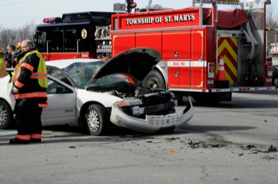
A Plymouth car sits at the intersection of state Route 703 and Koenig Road in St. Marys Township on Tuesday afternoon after a two-vehicle accident that also involved a Chevrolet SUV. At least one person was injured and taken to Joint Township District Memorial Hospital, St. Marys, according to St. Marys Police Chief Mark Ernst. St. Marys police, St. Marys Township Fire Department and highway patrol officers responded to the accident. A full accident report is pending from the Ohio State Highway Patrol.

Additional pictures on this date