Special Weather Statement issued September 3 at 6:46PM EDT by NWS Wilmington OH (details ...)
At 646 PM EDT, strong thunderstorms were located along a line extending from near Van Wert to near Monroe, moving southeast at 30 mph. HAZARD...Wind gusts up to 45 mph, frequent cloud-to-ground lightning, and very heavy rain. SOURCE...Radar indicated. IMPACT...Gusty winds could knock down tree limbs and blow around unsecured objects. Lightning can cause serious injury or death. Visibility will be poor and hydroplaning is possible. Locations impacted include... Rockford, Mendon, Chattanooga, and Tama. If outdoors, consider seeking shelter inside a sturdy building. Motorists should slow down and use extra caution. When thunder roars, go indoors! Do not stay in the open or seek shelter under trees when lightning threatens. To report hazardous weather conditions, go to our website at weather.gov/iln and submit your report via social media, when you can do so safely.
Heat Advisory issued September 3 at 3:40PM EDT until September 3 at 8:00PM EDT by NWS Wilmington OH (details ...)
* WHAT...Heat index values of 100 to 105 expected. * WHERE...Delaware, Licking, Union, Auglaize, Champaign, Hardin, Logan, Mercer, and Shelby Counties. * WHEN...Until 8 PM EDT this evening. * IMPACTS...Hot temperatures and high humidity may cause heat illnesses.
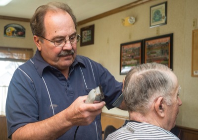
COLDWATER - Bob Hein has no plans to cut short his time as a barber.
On Wednesday, he marked 50 years of being a barber at his cozy, one-chair shop in downtown Coldwater. It was a big milestone but Hein didn't make a fuss about it.
CELINA - Celina City Schools students will return to paper and pencil testing for state assessments due to concerns the online format negatively affects scores.
CELINA - Several local governments are banding together to pursue $190,000 in state funds to help buy a new ambulance for the St. Henry EMS squad, which serves their territory.