Special Weather Statement issued May 1 at 12:13PM EDT by NWS Wilmington OH (details ...)
At 1212 PM EDT, a strong thunderstorm was located near New Bremen, moving northeast at 50 mph.
HAZARD...Wind gusts up to 45 mph and pea size hail.
SOURCE...Radar indicated.
IMPACT...Gusty winds could knock down tree limbs and blow around unsecured objects. Hail may cause minor damage to vegetation.
Locations impacted include... Newport, Fryburg, Montra, Egypt, Uniopolis, New Bremen, Buckland, Botkins, New Knoxville, Fort Loramie, Kettlersville, Moulton, Jackson Center, St. Marys, Anna, Kossuth, Lakeview, Lake Loramie State Park, Waynesfield, and Wapakoneta.
This includes I-75 in Ohio between mile markers 96 and 118.
If outdoors, consider seeking shelter inside a sturdy building.
To report hazardous weather conditions, go to our website at weather.gov/iln and submit your report via social media, when you can do so safely.
Today 74° Today 74° 58° 58° chance Tomorrow 71° Tomorrow 71° chance 54° 54° chance
Wednesday, May 4th, 2016
Photo by Mark Pummell/The Daily Standard

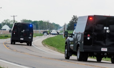
Two Allen County Sheriff's Office Bomb Squad vehicles travel west on state Route 119 on Tuesday afternoon to assist Auglaize County officials in checking a residence for possible explosives. Officials remained at the scene until at least 6:30 p.m.

Related online story:
MINSTER - A nearly four-hour standoff and negotiations with a reportedly suicidal 38-year-old man ended with a surrender and a trip to a hospital. [More]
Additional pictures on this date