Flood Watch issued August 11 at 4:12AM EDT until August 12 at 8:00AM EDT by NWS Wilmington OH (details ...)
* WHAT...Flash flooding caused by excessive rainfall continues to be possible.
* WHERE...Portions of Indiana, including the following counties, Dearborn, Fayette, Franklin, Union and Wayne, Kentucky, including the following counties, Boone, Bracken, Campbell, Kenton, Lewis, Mason, Pendleton and Robertson, and Ohio, including the following counties, Adams, Auglaize, Brown, Butler, Champaign, Clark, Clermont, Clinton, Darke, Delaware, Fairfield, Fayette, Franklin, Greene, Hamilton, Hardin, Highland, Hocking, Licking, Logan, Madison, Mercer, Miami, Montgomery, Pickaway, Pike, Preble, Ross, Scioto, Shelby, Union and Warren.
* WHEN...Through Wednesday morning.
* IMPACTS...Excessive runoff may result in flooding of rivers, creeks, streams, and other low-lying and flood-prone locations.
* ADDITIONAL DETAILS... - Several rounds of thunderstorms are expected into Wednesday morning. Locally heavy rainfall can be expected with the potential for storms to repeatedly track over the same locations. This will result in the potential for flash flooding.
Today 83° Today 83° chance 66° 66° chance Tomorrow 83° Tomorrow 83° slight chance slight chance 66° 66° chance likely
Monday, May 9th, 2016
Powerful tour
Photo by Jared Mauch/The Daily Standard

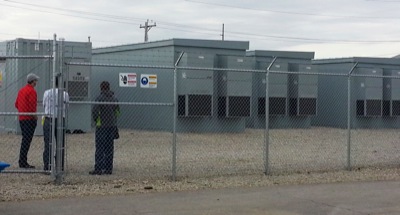
A group of people look at the energy-storage units on the west side of North Ohio Street in Minster during Saturday morning's open house. Residents spoke to village officials and energy company representatives during the event. Construction was completed earlier this year and $10 million was funded by Half Moon Ventures of Chicago.


Additional pictures on this date