Severe Thunderstorm Watch issued April 14 at 5:16PM EDT until April 14 at 11:00PM EDT by NWS Wilmington OH (details ...)
THE NATIONAL WEATHER SERVICE HAS ISSUED SEVERE THUNDERSTORM WATCH 112 IN EFFECT UNTIL 11 PM EDT THIS EVENING FOR THE FOLLOWING AREAS
IN INDIANA THIS WATCH INCLUDES 4 COUNTIES
IN EAST CENTRAL INDIANA
FAYETTE UNION WAYNE
IN SOUTHEAST INDIANA
FRANKLIN
IN OHIO THIS WATCH INCLUDES 7 COUNTIES
IN WEST CENTRAL OHIO
AUGLAIZE DARKE MERCER MIAMI MONTGOMERY PREBLE SHELBY
THIS INCLUDES THE CITIES OF BROOKVILLE, CAMDEN, CELINA, COLDWATER, CONNERSVILLE, DOWNTOWN DAYTON, EATON, GREENVILLE, KETTERING, LIBERTY, MINSTER, NEW BREMEN, PIQUA, RICHMOND, SIDNEY, ST. MARYS, TIPP CITY, TROY, WAPAKONETA, AND WEST COLLEGE CORNER.
Today 82° Today 82° chance 67° 67° chance Tomorrow 83° Tomorrow 83° likely 66° 66° likely
Saturday, October 15th, 2016
Photo by Mark Pummell/The Daily Standard

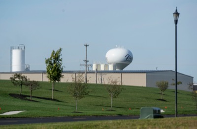
A portion of the Dannon Company plant in Minster is seen beyond a barrier mound that is on the south side of First Street in Minster. A portion of the mound is planned to be removed in the future for a personnel vehicle access drive, according to a Dannon representative.

Related online story:
MINSTER - The Dannon Company officials will host a public meeting soon to address construction concerns residents may have about a proposed new distribution center. [More]
Additional pictures on this date