Extreme Heat Watch issued June 20 at 3:15AM EDT until June 24 at 8:00PM EDT by NWS Wilmington OH (details ...)
* WHAT...Dangerously hot conditions with heat index values up to 104 possible.
* WHERE...Portions of east central and southeast Indiana, northeast and northern Kentucky, and central, south central, southwest, and west central Ohio.
* WHEN...From Sunday afternoon through Tuesday evening.
* IMPACTS...Heat related illnesses increase significantly during extreme heat and high humidity events, particularly for those working or participating in outdoor activities.
* ADDITIONAL DETAILS...Consecutive days of excessive heat and humidity combined with very warm low temperatures can be especially hazardous as the overnight hours provide little relief from the heat. The heat may continue into Wednesday.
63° 63° slight chance Fri 84° Fri 84° 68° 68° Sat 89° Sat 89°
Monday, October 24th, 2016
Photo by Mark Pummell/The Daily Standard

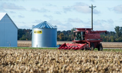
A combine rests in a cornfield along U.S. 127 north of Celina on Friday. Ag officials say many farmers will experience lower corn yields due to this summer's drought. Soybeans fared better than corn, especially in Mercer County. Many farmers had to suspend harvesting crops due to recent rain.

Related online story:
Ag officials in Mercer and Auglaize counties said they expect this year's overall corn yields to be down 25 to 30 percent due to the drought.
Overall Auglaize County soybean yields will be reduced an estimated 20 percent. [More]
Additional pictures on this date