Flood Watch issued August 13 at 4:50AM EDT until August 14 at 11:00AM EDT by NWS Wilmington OH (details ...)
* WHAT...Flash flooding caused by excessive rainfall continues to be possible.
* WHERE...Portions of Indiana, including the following counties, Dearborn, Fayette, Franklin, Ohio, Ripley, Switzerland, Union and Wayne, Kentucky, including the following counties, Boone, Bracken, Campbell, Carroll, Gallatin, Grant, Kenton, Lewis, Mason, Owen, Pendleton and Robertson, and Ohio, including the following counties, Adams, Auglaize, Brown, Butler, Champaign, Clark, Clermont, Clinton, Darke, Delaware, Fairfield, Fayette, Franklin, Greene, Hamilton, Hardin, Highland, Hocking, Licking, Logan, Madison, Mercer, Miami, Montgomery, Pickaway, Pike, Preble, Ross, Scioto, Shelby, Union and Warren.
* WHEN...Through Friday morning.
* IMPACTS...Excessive runoff may result in flooding of rivers, creeks, streams, and other low-lying and flood-prone locations. Area creeks and streams are running high and could flood with more heavy rain.
* ADDITIONAL DETAILS... - A lull in rainfall will continue for much of the day. However, additional storms will move into the area later this afternoon. The risk of heavy rainfall will be greatest tonight into early Friday morning. There is also the potential for storms to repeatedly move over the same locations, which increases flash flood risk.
Today 83° Today 83° chance 69° 69° chance likely Tomorrow 81° Tomorrow 81° chance likely 68° 68° chance
Saturday, May 6th, 2017
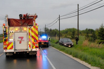
One injured in crash
Photo by Amy Kronenberger/The Daily Standard

Celina fire and rescue personnel respond to a single-vehicle injury accident at approximately 7:35 p.m. Friday on state Route 703 near Harris Road. One person was transported by EMS to a hospital. No further information was available Friday night.

Additional pictures on this date