Special Weather Statement issued May 18 at 4:44PM EDT by NWS Wilmington OH (details ...)
At 444 PM EDT, strong thunderstorms were located along a line extending from near Spencerville In Allen County to near Union City, moving east at 30 mph.
HAZARD...Wind gusts up to 50 mph, pea size hail, frequent cloud-to-ground lightning, and very heavy rain.
SOURCE...Radar indicated.
IMPACT...Gusty winds could knock down tree limbs and blow around unsecured objects. Hail may cause minor damage to vegetation. Lightning can cause serious injury or death. Visibility will be poor and hydroplaning is possible.
Locations impacted include... Greenville, Celina, Wapakoneta, St. Marys, Coldwater, Fort Shawnee, New Bremen, St. Henry, Cridersville, Union City, Ansonia, New Knoxville, Moulton, Wayne Lakes, Mendon, Chickasaw, Burkettsville, North Star, Buckland, and Rossburg.
This includes I-75 in Ohio between mile markers 114 and 118.
If outdoors, consider seeking shelter inside a sturdy building.
Motorists should slow down and use extra caution.
When thunder roars, go indoors! Do not stay in the open or seek shelter under trees when lightning threatens.
A Severe Thunderstorm Watch remains in effect until 600 PM EDT for west central Ohio.
To report hazardous weather conditions, go to our website at weather.gov/iln and submit your report via social media, when you can do so safely.
Special Weather Statement issued May 18 at 4:38PM EDT by NWS Wilmington OH (details ...)
At 438 PM EDT, strong thunderstorms were located along a line extending from 7 miles west of Fort Loramie to near Greenville, moving northeast at 40 mph.
HAZARD...Wind gusts up to 40 mph and pea size hail.
SOURCE...Radar indicated.
IMPACT...Gusty winds could knock down tree limbs and blow around unsecured objects. Hail may cause minor damage to vegetation.
Locations impacted include... Greenville, Wapakoneta, New Bremen, Minster, Versailles, Newport, Bradford, Fort Loramie, New Knoxville, Webster, Wayne Lakes, Russia, Gettysburg, Osgood, North Star, Kettlersville, Yorkshire, Egypt, Darke County Airport, and State Route 47 at US Route 127.
If outdoors, consider seeking shelter inside a sturdy building.
A Severe Thunderstorm Watch remains in effect until 600 PM EDT for west central Ohio.
To report hazardous weather conditions, go to our website at weather.gov/iln and submit your report via social media, when you can do so safely.
Severe Thunderstorm Watch issued May 18 at 11:11AM EDT until May 18 at 6:00PM EDT by NWS Wilmington OH (details ...)
THE NATIONAL WEATHER SERVICE HAS ISSUED SEVERE THUNDERSTORM WATCH 220 IN EFFECT UNTIL 6 PM EDT THIS EVENING FOR THE FOLLOWING AREAS
IN OHIO THIS WATCH INCLUDES 2 COUNTIES
IN WEST CENTRAL OHIO
AUGLAIZE MERCER
THIS INCLUDES THE CITIES OF CELINA, COLDWATER, MINSTER, NEW BREMEN, ST. MARYS, AND WAPAKONETA.
Today 87° Today 87° chance 68° 68° chance Tomorrow 87° Tomorrow 87° likely 59° 59°
Friday, December 22nd, 2017
The cabins come tumbling down
Photo by Mark Pummell/The Daily Standard

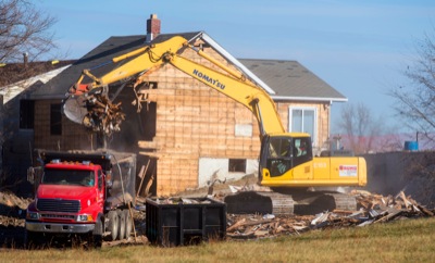
Bruns Building & Development crews on Thursday demolish the company's remaining cabins along Celina's West Bank Road to make way for a new condominium/hotel-style resort called the Boardwalk Resort. Developers say they're on track for a fall 2018 opening.

Additional pictures on this date