Flood Watch issued September 16 at 2:55PM EDT until September 17 at 2:00PM EDT by NWS Wilmington OH (details ...)
* WHAT...Flash flooding caused by excessive rainfall is possible.
* WHERE...Portions of east central Indiana, including the following county, Wayne and Ohio, including the following counties, Auglaize, Champaign, Clark, Darke, Delaware, Franklin, Greene, Hardin, Licking, Logan, Madison, Mercer, Miami, Montgomery, Preble, Shelby and Union.
* WHEN...From midnight EDT tonight through Thursday afternoon.
* IMPACTS...Excessive runoff may result in flooding of rivers, creeks, streams, and other low-lying and flood-prone locations.
* ADDITIONAL DETAILS... - Multiple rounds of rain will occur overnight into Thursday. The heavier bands of rainfall will have 2 to 4 inches with locally higher amounts.
Today 86° Today 86° chance likely 70° 70° chance Tomorrow 84° Tomorrow 84° chance 67° 67° slight chance
Thursday, March 15th, 2018
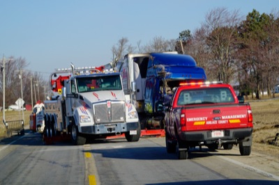
Crash blocks highway
Photo by Ed Gebert/The Daily Standard

The Ohio State Highway Patrol responded to a report of a single-vehicle tractor-trailer crash with injuries at 4:23 a.m. today on U.S. 33 just east of the Mercer-Auglaize county line. At least one person was transported by ambulance to a local hospital, according to officials on the scene. U.S. 33 was closed for more than five hours while crews cleaned up the site. Traffic delays caused Celina City Schools bus No 31 to run about 10 minutes late.


Additional pictures on this date