Flood Watch issued August 12 at 9:17AM EDT until August 12 at 11:00PM EDT by NWS Wilmington OH (details ...)
* WHAT...Flash flooding caused by excessive rainfall continues to be possible.
* WHERE...Portions of Indiana, including the following counties, Dearborn, Fayette, Franklin, Ohio, Ripley, Switzerland, Union and Wayne, Kentucky, including the following counties, Boone, Bracken, Campbell, Carroll, Gallatin, Grant, Kenton, Lewis, Mason, Owen, Pendleton and Robertson, and Ohio, including the following counties, Adams, Auglaize, Brown, Butler, Champaign, Clark, Clermont, Clinton, Darke, Delaware, Fairfield, Fayette, Franklin, Greene, Hamilton, Hardin, Highland, Hocking, Licking, Logan, Madison, Mercer, Miami, Montgomery, Pickaway, Pike, Preble, Ross, Scioto, Shelby, Union and Warren.
* WHEN...Through this evening.
* IMPACTS...Excessive runoff may result in flooding of rivers, creeks, streams, and other low-lying and flood-prone locations.
* ADDITIONAL DETAILS... - Additional thunderstorms are expected into this evening. Locally heavy rainfall and the potential for storms to repeatedly track over the same areas are possible. This will result in the potential for flash flooding.
Flood Advisory issued August 12 at 8:10AM EDT until August 12 at 11:15AM EDT by NWS Wilmington OH (details ...)
* WHAT...Flooding caused by excessive rainfall is expected.
* WHERE...Southwestern Auglaize County in west central Ohio... Darke County in west central Ohio... Mercer County in west central Ohio... Miami County in west central Ohio... Northeastern Preble County in west central Ohio... Western Shelby County in west central Ohio...
* WHEN...Until 1115 AM EDT.
* IMPACTS...Minor flooding in low-lying and poor drainage areas.
* ADDITIONAL DETAILS... - At 810 AM EDT, radar indicated heavy rain due to thunderstorms. Minor flooding is ongoing or expected to begin shortly in the advisory area. Between 1 and 1.5 inches of rain have fallen. Additional rainfall amounts of 1 to 1.5 inches are possible. - Some locations that may experience flooding include... Troy, Piqua, Greenville, Celina, Tipp City, St. Marys, West Milton, Coldwater, New Bremen, Minster, Versailles, Covington, St. Henry, Arcanum, Newport, Bradford, Union City, Fort Loramie, Fort Recovery and Pleasant Hill.
Special Weather Statement issued August 12 at 9:09AM EDT by NWS Wilmington OH (details ...)
At 909 AM EDT, a strong thunderstorm was located over Botkins, moving southeast at 40 mph.
HAZARD...Penny size hail, frequent cloud-to-ground lightning, and very heavy rain.
SOURCE...Radar indicated.
IMPACT...Hail may cause minor damage to vegetation. Lightning can cause serious injury or death. Visibility will be poor and hydroplaning is possible.
Locations impacted include... Bellefontaine, Wapakoneta, Anna, Jackson Center, Russells Point, De Graff, Botkins, Lakeview, Quincy, Huntsville, Port Jefferson, Kettlersville, Fryburg, Montra, Logansville, Mcmorran, Maplewood, Mccartyville, Swanders, and Bloom Center.
This includes I-75 in Ohio between mile markers 97 and 110.
If outdoors, consider seeking shelter inside a sturdy building.
Motorists should slow down and use extra caution.
When thunder roars, go indoors! Do not stay in the open or seek shelter under trees when lightning threatens.
To report hazardous weather conditions, go to our website at weather.gov/iln and submit your report via social media, when you can do so safely.
Today 83° Today 83° likely 68° 68° slight chance chance Tomorrow 81° Tomorrow 81° chance chance 68° 68° chance
Saturday, June 9th, 2018
Ex-school building turned into venue for conferences, retreats, other events
By Tom Stankard
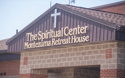
MONTEZUMA - The public is invited to tour the new Spiritual Center of Montezuma, an annex of the Spiritual Center of Maria Stein.
An open house slated for 2-7 p.m. June 20-21 will allow people to see the completed renovations of the facility that previously was Celina City Schools' Franklin Building, Spiritual Center director Robin Goettemoeller said. The center is located at 6732 State Route 219. [More]
Obituaries on June 9th, 2018
Helen E. Johnson, 84, Fort Recovery, died on June 8, 2018, at Mercer County Community Hospital, Coldwater. [More]
Local pictures on June 9th, 2018
Subscriber stories on June 9th, 2018
Wood statue treated, revamped after ant infestation
COLDWATER - A popular wooden statue of St. Francis of Assisi is back up within Memorial Park among the trees, birds and squirrels after having been taken down months ago for treatment.
CELINA - Mercer County Commissioners recently approved a $28,080.08 change order for a tile replacement project, bumping up VTF Excavation's contract to $427,273.82.
ST. HENRY - Village fire chief Matt Lefeld on Friday warned area residents of scam phone calls soliciting donations for the town fire department.
Late Model Dream Week
ROSSBURG - Mother Nature finally cooperated a little as the 24th annual Dirt Late Model Dream began Friday at Eldora Speedway after Thursday's races were postponed to Friday afternoon. Friday's scheduled program followed with two 25-lap features paying $10,000 to the winner of each race.
Rain gets another win on baseball schedule
Compiled by Gary R. Rasberry
The Minster ACME baseball team went 2-1 on Friday as the Wildcats continued their Tennessee trip with games at Pigeon Forge High School.