Winter Storm Warning issued January 24 at 2:16AM EST until January 26 at 12:00PM EST by NWS Wilmington OH (details ...)
* WHAT...Heavy snow expected. Total snow accumulations between 6 and 10 inches.
* WHERE...Auglaize, Darke, Hardin, Logan, Mercer, and Shelby Counties.
* WHEN...From 10 AM this morning to noon EST Monday.
* IMPACTS...Travel could be very difficult. The hazardous conditions could impact the Monday morning commute.
Cold Weather Advisory issued January 24 at 2:12AM EST until January 24 at 12:00PM EST by NWS Wilmington OH (details ...)
* WHAT...Very cold wind chills as low as 15 below zero.
* WHERE...In Indiana, Wayne County. In Ohio, Auglaize, Darke, Hardin, Logan, Mercer, and Shelby Counties.
* WHEN...Until noon EST today.
* IMPACTS...The cold wind chills could result in hypothermia if precautions are not taken.
Today 11° Today 11° slight chance Tomorrow 15° Tomorrow 15° heavy heavy
Saturday, July 21st, 2018
Fender bender
Photo by Ed Gebert/The Daily Standard

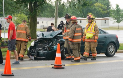
No one was injured when a car collided with an SUV near 700 N. Second St. in Coldwater just before 5 p.m. Friday. The SUV had to be driven to remove it from the hood of the car. Further details were not available at press time.

Additional picture on this date