Special Weather Statement issued October 21 at 4:34PM EDT by NWS Wilmington OH (details ...)
At 434 PM EDT, strong thunderstorms were located along a line extending from near Delphos to near Versailles, moving east at 40 mph. HAZARD...Wind gusts up to 45 mph. SOURCE...Radar indicated. IMPACT...Gusty winds could knock down tree limbs and blow around unsecured objects. Locations impacted include... Sidney, Wapakoneta, St. Marys, Ada, Fort Shawnee, New Bremen, Minster, Newport, Cridersville, Anna, Fort Loramie, Jackson Center, Russells Point, De Graff, Botkins, Lakeview, New Knoxville, Alger, Waynesfield, and Chippewa Park. This includes I-75 in Ohio between mile markers 91 and 118. If outdoors, consider seeking shelter inside a sturdy building. To report hazardous weather conditions, go to our website at weather.gov/iln and submit your report via social media, when you can do so safely.
Thursday, August 23rd, 2018
Photo by Tom Stankard/The Daily Standard
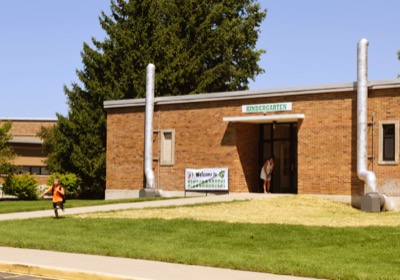
A student leaves Celina Primary School after the first day of classes on Wednesday. The district has installed radon mitigation systems at the building as well as at the middle school and education complex.
CELINA - School district officials have detected higher-than-recommended levels of radon at the primary and middle schools and the education complex, leading to the installation of mitigation systems at each building. [More]