Special Weather Statement issued May 1 at 12:13PM EDT by NWS Wilmington OH (details ...)
At 1212 PM EDT, a strong thunderstorm was located near New Bremen, moving northeast at 50 mph.
HAZARD...Wind gusts up to 45 mph and pea size hail.
SOURCE...Radar indicated.
IMPACT...Gusty winds could knock down tree limbs and blow around unsecured objects. Hail may cause minor damage to vegetation.
Locations impacted include... Newport, Fryburg, Montra, Egypt, Uniopolis, New Bremen, Buckland, Botkins, New Knoxville, Fort Loramie, Kettlersville, Moulton, Jackson Center, St. Marys, Anna, Kossuth, Lakeview, Lake Loramie State Park, Waynesfield, and Wapakoneta.
This includes I-75 in Ohio between mile markers 96 and 118.
If outdoors, consider seeking shelter inside a sturdy building.
To report hazardous weather conditions, go to our website at weather.gov/iln and submit your report via social media, when you can do so safely.
Today 74° Today 74° 58° 58° chance Tomorrow 71° Tomorrow 71° chance 54° 54° chance
Wednesday, January 9th, 2019
Rollover crash
Photo by Dan Melograna/The Daily Standard

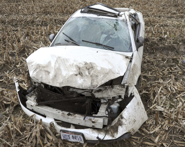
A car rests in a field after rolling over in a Tuesday afternoon accident near the Mercer County Sheriff's Office along State Route 29 west of Celina. The eastbound car's driver steered the vehicle off the road to avoid a collision with a stopped vehicle as that driver prepared to turn into the sheriff's office, according to deputy Jason Seger. The driver suffered minor injuries and was transported to Mercer County Community Hospital in Coldwater, Seger said.

Additional pictures on this date