Winter Storm Warning issued January 24 at 1:49PM EST until January 26 at 12:00PM EST by NWS Wilmington OH (details ...)
* WHAT...Heavy snow. Snow accumulations between 9 and 11 inches.
* WHERE...Auglaize, Darke, Hardin, Logan, Mercer, and Shelby Counties.
* WHEN...Until noon EST Monday.
* IMPACTS...Travel could be very difficult. The hazardous conditions could impact the Monday morning commute.
Cold Weather Advisory issued January 24 at 1:32PM EST until January 26 at 6:00PM EST by NWS Wilmington OH (details ...)
* WHAT...For the Cold Weather Advisory, very cold wind chills as low as around 15 below zero expected. For the Extreme Cold Watch, dangerously cold wind chills as low as around 25 below zero possible.
* WHERE...Portions of east central and southeast Indiana, northeast and northern Kentucky, and central, south central, southwest, and west central Ohio.
* WHEN...For the Cold Weather Advisory, from midnight Sunday Night to 6 PM EST Monday. For the Extreme Cold Watch, from Monday evening through Tuesday morning.
* IMPACTS...The dangerously cold wind chills could cause frostbite on exposed skin in as little as 30 minutes.
Extreme Cold Watch issued January 24 at 1:32PM EST until January 27 at 12:00PM EST by NWS Wilmington OH (details ...)
* WHAT...For the Cold Weather Advisory, very cold wind chills as low as around 15 below zero expected. For the Extreme Cold Watch, dangerously cold wind chills as low as around 25 below zero possible.
* WHERE...Portions of east central and southeast Indiana, northeast and northern Kentucky, and central, south central, southwest, and west central Ohio.
* WHEN...For the Cold Weather Advisory, from midnight Sunday Night to 6 PM EST Monday. For the Extreme Cold Watch, from Monday evening through Tuesday morning.
* IMPACTS...The dangerously cold wind chills could cause frostbite on exposed skin in as little as 30 minutes.
Today 11° Today 11° slight chance Tomorrow 15° Tomorrow 15° heavy heavy
Wednesday, April 10th, 2019
Scrambled eggs
Photo by Leslie Gartrell/The Daily Standard

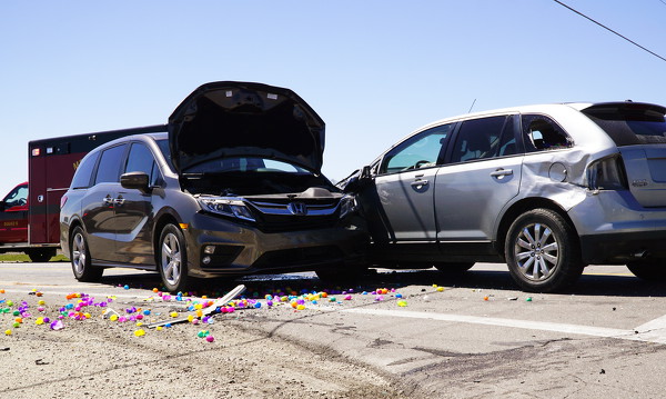
A three-car accident at the intersection of state routes 118 South and 29 left one person injured on Tuesday afternoon. The individual was transported to Mercer County Community Hospital, Coldwater, with a head injury, a first responder said. The accident also destroyed dozens of plastic Easter eggs that were being transported in one of the vehicles. No further information was available at press time.

Additional pictures on this date